Parking
Park at the Skaftafell Visitor Centre (paid; kiosks/app/online payment). The trail starts behind the campground.

#8 of 16 trails in Vatnajökull
Vatnajökull National Park
Basalt falls, big views, and turf houses in one tidy loop
Overview
This is Skaftafell’s greatest hits in one loop: the famous basalt‑column waterfall Svartifoss, airy panoramas from Sjónarsker, and a quiet detour by the old turf houses at Sel. The full loop is about 5.8 km (3.6 miles) total with roughly 200–250 m of climbing, taking most hikers 1.5–3 hours depending on how long you linger at viewpoints. Expect a steady grade, lots of steps, and crowds up to Svartifoss that thin out as soon as you continue the loop.
Map & elevation
Plan your hike

The highest, rockiest slopes around here are a summer buffet for grizzly bears.
Vatnajökull Tour Guide
Parkwolf is a GPS audio tour guide for Vatnajökull National Park. As you drive, it chimes in with what’s ahead: hidden gems, upcoming stops, history, geology, and wildlife, right through your car’s speakers.
Recorded for this trailhead
Welcome to the Skaftafell Visitor Center Area“You're pulling into the Skaftafell area, which is the main basecamp for exploring the glaciers and waterfalls nearby. The large building is the visitor center, and it's the best place to start to get oriented.”
Plays as you drive up to this trailhead in the Parkwolf Vatnajökull Tour Guide.
More stories near here in the app
“Fantastic app with many points of information… It’s great to just turn on while you’re driving and it gives you an audio tour of the national Park. We love it!!!!”


Trail guide
Svartifoss steals the show with its striking dark, hexagonal basalt columns—lava that cooled slowly around 300,000 years ago. You’ll also pass Hundafoss and Magnúsarfoss on the approach, then gain a broad, all-directions outlook at Sjónarsker on a clear day. The loop’s character changes nicely after the falls: more open views, fewer people, and a peek into local heritage at the sod‑roofed buildings in Sel before returning via Lambhagi.
Start at the Skaftafell Visitor Centre. The first 250 m run through the campground before a right turn and a sustained uphill toward the Svartifoss viewpoint. From there, drop into the ravine, cross the footbridge, and climb the basalt‑like steps opposite the falls for closer views. Continue to Sjónarsker for panoramas, then descend toward Sel and follow signs back to the visitor centre via Lambhagi. The path is well marked and generally wide enough for 2–3 people to walk abreast.
Call it moderate: firm tread (compacted soil/mats) with many wooden and stone steps. It’s straightforward but can feel punchy if you’re stair‑averse or not used to climbing. Surfaces get slippery when wet and can be icy or snow‑covered in winter; traction and poles help. The first 1.5 km climbs about 140 m to the Svartifoss viewpoint, so pace yourself.
Parking is at the Skaftafell Visitor Centre (paid; expect a fee). Facilities there include restrooms, information, a small shop, and a cafeteria. There’s no separate admission fee for walking the trail. If you’re short on time, the out‑and‑back to Svartifoss alone is about 3.4 km (2.1 miles) total—expect the highest foot traffic on that segment.
Wildlife
 22 sightingsGrey SealMost seen around 5 AMSighting map
 258 sightingsHarbor SealMost seen around 11 AMSighting map
 184 sightingsCaribouMost seen around 7 PMSighting map
 62 sightingsArctic FoxMost seen around 8 PMSighting map
 168 sightingsWhooper SwanMost seen around 5 PMSighting map
 68 sightingsAtlantic PuffinMost seen around 7 PMSighting map
Sighting maps show where each species has been reported across Vatnajökull. Wildlife moves, so no sighting is guaranteed.
Keep exploring
 EasySkaftafellsjökull Glacier4.1 km · 1.5 hr · At the trailheadEasy circular glacier trail with interpretive stops and close Skaftafellsjökull views
 ModerateSvartifoss Waterfall (Skaftafell)3.9 km · 1.5 hr · At the trailheadA short, sustained climb from Skaftafell Visitor Centre to Iceland’s basalt-framed waterfall.
 ChallengingKristínartindar Trail (S4)17.9 km · 7 hr · At the trailheadA demanding 17.9 km loop from Skaftafellsstofa to Kristínartindar’s steep summit ridge, with glacier views throughout.
 ChallengingMorsárjökull via Morsárdalur19.6 km · 6.5 hr · At the trailheadComplete M2 loop from Skaftafell to Morsárjökull’s glacier-lake viewpoint
 ModerateSjónarnípa Viewpoint Trail (S6)7.5 km · 2.8 hr · At the trailheadSvartifoss and a cliff-top glacier overlook in one challenging loop.
 Visitor center · At the trailheadSkaftafellsstofa Visitor CenterThe hub for trail info, exhibits, and a warm pre-hike coffee
 Campground · 0.3 km awaySkaftafell CampgroundBig, well-situated basecamp for hikes and glacier adventures
 Sight · 0.8 km awayHundafossPretty gorge waterfall on the Svartifoss trail, best from the west
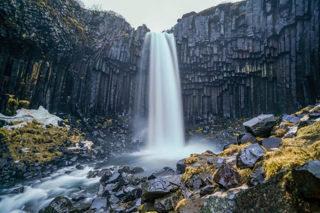 Sight · 1.3 km awaySvartifossBasalt-column waterfall via a short, rewarding Skaftafell hike
 Sight · 2.7 km awaySkaftafellsjökull ViewpointEasy walk to a glacier lagoon with booming, ash-streaked ice
 Sight · 3.6 km awaySkeiðarárbrúTwisted bridge girder and big glacier views on the sandur plain
 Gas station · 4.4 km awayFreysnesOne-stop fuel, food, and tour meet-up near Skaftafell
 Sight · 4.5 km awaySvínafellsjökull ViewpointShort walk to a blue-ice glacier tongue and lagoon
Parkwolf’s Vatnajökull ranking

The audio tour guide for the drive, plus offline maps, trails, and wildlife heatmaps for when the signal drops.