Parking
Start/end at Rarakau Car Park (about 30 minutes from Tuatapere); parking available at the trailhead.
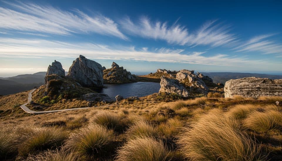
Fiordland National Park, SL
Coast-to-alpine loop with big views, heritage viaducts, and comfy lodges.
Overview
If you want a true Fiordland sampler—wild Southern Ocean beaches, ancient podocarp forest, and airy ridge walking—all in one go, this 61.5 km (38.2-mile) loop delivers. It is a challenging three-day, two-night tramp with a substantial climb from sea level to the Hump Ridge, but the payoff is big: panoramic views toward Fiordland’s mountains, the Southland Plains, and Stewart Island on clear days. It is quieter than the headline Great Walks and has a strong sense of remoteness.
 Parkwolf’s verdictWhy this track
Map & elevation
Plan your hike

The highest, rockiest slopes around here are a summer buffet for grizzly bears.
Fiordland Tour Guide
Parkwolf is a GPS audio tour guide for Fiordland National Park. As you drive, it chimes in with what’s ahead: hidden gems, upcoming stops, history, geology, and wildlife, right through your car’s speakers.
See the Fiordland audio tour“Fantastic app with many points of information… It’s great to just turn on while you’re driving and it gives you an audio tour of the national Park. We love it!!!!”


Trail guide
The route climbs from Rarakau Car Park through lush coastal bush to the sub-alpine tops near Okaka Lodge, where boardwalk and tarns lead past sandstone and schist outcrops shaped by tectonic uplift and glacial work. Down low, you’ll walk beachfront sections and cross clear rivers; along the coast, historic timber viaducts such as Percy Burn and Edwin Burn recall the area’s logging past. Expect a mix of rugged coastline, ancient forest, peat bogs on the tops, and big-sky ridge views.
Plan for long days and real effort. The track is rated moderate to challenging, with roughly 1,000 m of ascent on the first day and plenty of uneven ground, mud, roots, and old railway sleeper sections near the viaducts. The circuit starts and ends at Rarakau Car Park and retraces part of the route on the final leg, so expect some déjà vu. The official visitor distance is 61.5 km (38.2 miles) for the full loop; the complete OSM corridor stored here measures 57.86 km because mapped line distance and the operator’s visitor itinerary use different measurement conventions.
This is a managed Great Walk experience: pre-purchase a walking package through the Hump Ridge Track operator, with optional catering, guiding, and helicopter transfers. Okaka Lodge on the ridge and Port Craig Lodge on the coast offer more comfort than standard backcountry huts. Check the Department of Conservation and operator sites for current conditions, closures, hazards, and booking requirements before you go.
Start and finish at Rarakau Car Park, about 30 minutes from Tuatapere. The route is remote and exposed to changeable Fiordland weather, so carry suitable equipment and check official access information before departure.
Wildlife
 1,181 sightingsKeaMost seen around 10 AMSighting map
 199 sightingsFiordland PenguinMost seen around 7 PMSighting map
 228 sightingsBlue DuckMost seen around 5 PMSighting map
 32 sightingsBottlenose DolphinMost seen around 5 PMSighting map
 247 sightingsNew Zealand Fur SealMost seen around 6 PMSighting map
 58 sightingsKākāMost seen around 6 PMSighting map
Sighting maps show where each species has been reported across Fiordland. Wildlife moves, so no sighting is guaranteed.
Keep exploring
 ChallengingHump Ridge Track61.5 km · 1 day · At the trailheadCoast-to-alpine Great Walk with big views and comfy lodges
 ChallengingWaitutu Track34.4 km · 16 hr · At the trailheadRemote viaduct-and-forest tramp into Fiordland's wild south coast
 ChallengingSouth Coast Track61 km · 1 days · At the trailheadRugged south coast, tramway viaducts, dolphins, and deep mud.ChallengingLake Hauroko Lookout Track5.4 km · 3 hr · 18.8 km awayA steep, rough rainforest climb to a rugged panorama above Lake Hauroko
Parkwolf’s Fiordland ranking
The audio tour guide for the drive, plus offline maps, trails, and wildlife heatmaps for when the signal drops.


