Park Creek Trail in Glacier National Park

Glacier National Park, MT

Park Creek Trail

A gradual creekside route into Glacier’s remote Park Creek valley.

Length
11.5mi
Time
7hr
Elev. change
886ft
Difficulty
Moderate
  • No dogs
  • High point 4,770 ft

Hear the audio tour

A Beak That Pries Cones Open

Overview

About Park Creek Trail

Why go

  • A long, gradual creekside walk through a glacial valley
  • Backcountry camps and a Lake Isabel side trip extend the experience

Heads up

  • Remote junctions require careful access and exit planning

Map & elevation

The route

Loading the Glacier map
Full map
Elevation3,885–4,770 ft
TrailheadPark Creek Junction on South Boundary Trail48.30705, -113.60796
Keep this map with you offline in the Parkwolf app

Plan your hike

Before you go

Parking

There is no drive-up parking at either end of the 11.5-mile segment. Walton Ranger Station is the road-side access; follow the South Boundary Trail about 3.2 miles on foot to reach the western junction. The far end connects to Lake Isabel and Two Medicine Pass routes, so arrange an onward backcountry route.

Safety

This is a remote backcountry route with a Park Creek crossing near Upper Park Creek Camp and no road access at either endpoint. Check current trail and crossing conditions before setting out. Overnight camping requires a wilderness permit.

1 active Glacier alert

  • ClosureTwo Medicine Campground closed for 2026 constructionTwo Medicine Campground is closed throughout 2026 because of construction in the Two Medicine developed area.Official details
Glacier alerts
A park ranger sits on a dash-mounted phone, talking, as Parkwolf’s Tour Guide plays “Army Cutworm Moths: A Grizzly Bear Buffet” on Grand Loop Road below Dunraven Pass in Yellowstone
Parkwolf Tour GuideThe highest, rockiest slopes around here are a summer buffet for grizzly bears.

Glacier Tour Guide

Your drive to Park Creek Trail, narrated.

Parkwolf is a GPS audio tour guide for Glacier National Park. As you drive, it chimes in with what’s ahead: hidden gems, upcoming stops, history, geology, and wildlife, right through your car’s speakers.

See the Glacier audio tour

Recorded for this area

A Beak That Pries Cones Open
0:00 / 0:31
“A red crossbill's beak overlaps at the tips, and that odd shape helps it open cones. The bird slips its slightly open bill between two scales, then closes it.”

Plays on the road 0.8 mi from the trailhead in the Parkwolf Glacier Tour Guide.

More stories near here in the app

  • The Bird That Walks Down Trees
  • Walton and Scalplock Lookout Trailhead
  • The Fungus Behind the Mushroom
  • The Cone with Three-Pointed Tabs
  • 204 audio storiesacross Glacier’s roads, triggered by GPS as you drive
  • Wildlife heatmapsfor Grizzly Bear, Wolverine, Mountain Goat, and 13 more
  • Works offlinemaps, 157 trails, 91 places, and audio download before you lose signal
  • CarPlay readysimple controls built for the drive
★★★★★
“Our first time to glacier and we used the audio portion for Going to the Sun Road. Wonderful information with perfect advice of what to see and do along the road.”
PaisleyParkFanApp Store review
Download Parkwolf on the App StoreGet Parkwolf on Google Play

4.7 from 8,600+ ratings

Trail guide

Hiking Park Creek Trail

A remote valley routePark Creek Trail is an 11.

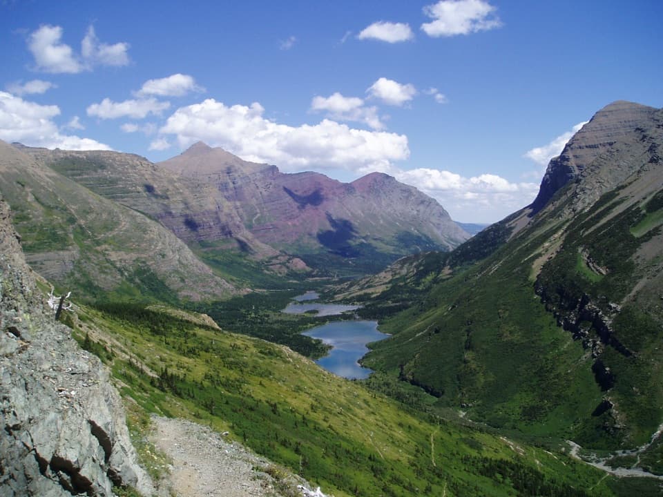
Park Creek Trail is an 11.5-mile, one-way point-to-point route from a remote junction on the Boundary trail network to the Lake Isabel junction near Upper Park Creek Camp. It follows a meandering creek through low country, climbing gradually beneath the peaks of a long glacial valley. Allow about seven hours for this leg, before the approach or onward route; this is a backcountry connection, not a parking-lot day hike.

Reach the start and plan the exitThere is no road access at either end of the Park Creek segment.

There is no road access at either end of the Park Creek segment. From Walton Ranger Station, the South Boundary Trail adds about 3.2 miles on foot to reach the western junction. The upper end meets the Lake Isabel trail and the Two Medicine Pass network, so plan a through-route or an appropriate return; do not expect a car waiting at the far end. A separate 26.3-mile Two Medicine-to-Walton itinerary includes Two Medicine Pass and other named trails, and is a longer multi-day route.

Follow the creekThe route winds beside Park Creek through low country with a slow, steady climb.

The route winds beside Park Creek through low country with a slow, steady climb. The deep glacial valley is lined by peaks, and Statuary Peak stands as a landmark toward the upper end. The walk is long and remote even though the grade is generally gradual.

Upper Park Creek and Lake IsabelNear Upper Park Creek Camp, the route crosses Park Creek and reaches the Lake Isabel junction.

Near Upper Park Creek Camp, the route crosses Park Creek and reaches the Lake Isabel junction. Lake Isabel is a separate 2.3-mile walk each way to a backcountry campground; that spur is not included in Park Creek’s 11.5 miles. Overnight camping in the park requires a wilderness permit, and pets are not allowed on park trails.

Wildlife

Wildlife in Glacier

All Glacier wildlife maps

Sighting maps show where each species has been reported across Glacier. Wildlife moves, so no sighting is guaranteed.

Parkwolf’s Glacier ranking

Top-rated trails in Glacier

All 157 trails
  1. 1Highline TrailChallenging · 11.8 mi
  2. 2Grinnell Glacier TrailChallenging · 10 mi
  3. 3Iceberg Lake TrailModerate · 9.6 mi
  4. 4Hidden Lake Overlook TrailModerate · 2.6 mi
  5. 5Avalanche Lake TrailModerate · 5 mi
  6. 6Trail of the CedarsEasy · 0.9 mi

Take Parkwolf to Glacier.

The audio tour guide for the drive, plus offline maps, trails, and wildlife heatmaps for when the signal drops.

4.7 from 8,600+ ratings

Download Parkwolf on the App StoreGet Parkwolf on Google Play