Aire River Day Visitor Area in Great Otway National Park

Picnic area · Great Otway National Park

Aire River Day Visitor Area

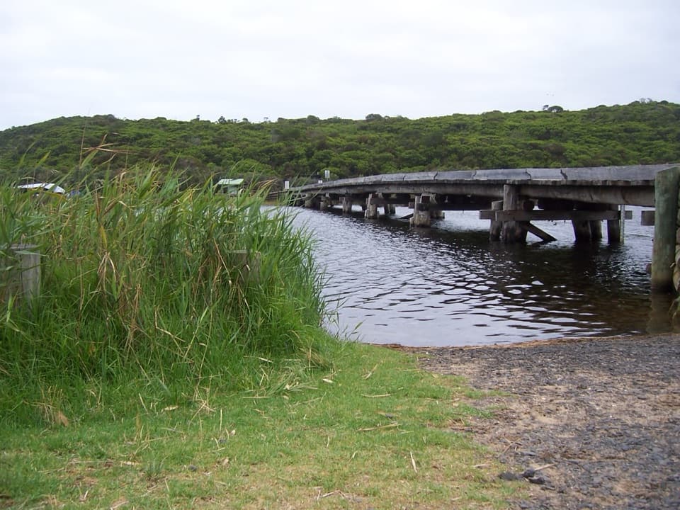
A riverside picnic stop framed by low Otway hills and wetlands.

Type
Picnic area
Nearest trail
Right here
Audio stories
5 nearby
  • Parking
  • Restrooms
  • Picnic tables

Hear the audio tour

Aire River: A Picnic by the Wetlands

Map

Where it is

Loading the Great Otway map
Full map
Picnic areaAire River Day Visitor Area-38.80202, 143.47666
Keep this map with you offline in the Parkwolf app

Plan your stop

Before you go

3 active Great Otway alerts

  • ClosureSeasonal campsite closures at Aire RiverMentions Aire River, referenced in this guideSeasonal closures remain in effect at Aire River through 30 October 2026; do not use the closed sites. - Aire River East: all sites are closed from 29 May to 30 October 2026 and reopen 31 October.Official details
  • ClosureWye Road closed after storm and flood damageWye Road is closed until further notice because recent storm and flood damage requires road maintenance and repair works; plan around the closure.Official details

See all 3 alerts
A park ranger sits on a dash-mounted phone, talking, as Parkwolf’s Tour Guide plays “Army Cutworm Moths: A Grizzly Bear Buffet” on Grand Loop Road below Dunraven Pass in Yellowstone
Parkwolf Tour GuideThe highest, rockiest slopes around here are a summer buffet for grizzly bears.

Great Otway Tour Guide

Your drive to Aire River Day Visitor Area, narrated.

Parkwolf is a GPS audio tour guide for Great Otway National Park. As you drive, it chimes in with what’s ahead: hidden gems, upcoming stops, history, geology, and wildlife, right through your car’s speakers.

See the Great Otway audio tour

Recorded for this place

Aire River: A Picnic by the Wetlands
0:00 / 0:27
“Up ahead is the Aire River day visitor area, a west-bank picnic stop beside Aire River West Campground. Stop here for a riverside break rather than a major sightseeing detour.”

Plays as you drive up to Aire River Day Visitor Area in the Parkwolf Great Otway Tour Guide.

More stories near here in the app

  • The Tiny Leaves on a Sheoak
  • The Cracks That Shape a Cliff
  • An Eagle Riding Rising Air
  • One Breeding Season for an Antechinus
  • 252 audio storiesacross Great Otway’s roads, triggered by GPS as you drive
  • Wildlife heatmapsfor Koala, Grey Kangaroo, Echidna, and 13 more
  • Works offlinemaps, 83 trails, 79 places, and audio download before you lose signal
  • CarPlay readysimple controls built for the drive
★★★★★
“Fantastic app with many points of information… It’s great to just turn on while you’re driving and it gives you an audio tour of the national Park. We love it!!!!”
JMJamesApp Store review
Download Parkwolf on the App StoreGet Parkwolf on Google Play

4.7 from 8,600+ ratings

Guide

More about Aire River Day Visitor Area

A west-bank picnic stopAire River Day Visitor Area is a riverside picnic spot on the western bank of the Aire, beside…

Aire River Day Visitor Area is a riverside picnic spot on the western bank of the Aire, beside Aire River West Campground in Great Otway National Park. It suits a simple sit-down break and a look over the river valley more than a dedicated sightseeing detour.

Make the stop workThe day-use area is on the western side; Aire River East Campground is a separate overnight…

The day-use area is on the western side; Aire River East Campground is a separate overnight site across the river. The managing authority describes level compacted-gravel parking near the picnic area, with an accessible toilet and standard cubicles in the day visitor area. Food service and potable water weren't confirmed for this day-use stop, so don't count on it as a resupply point.

A river valley shaped by three waterwaysThe Aire runs through a broad floodplain where the Aire, Calder and Ford river systems join…

The Aire runs through a broad floodplain where the Aire, Calder and Ford river systems join before reaching the Southern Ocean through an estuarine lake complex west of Cape Otway. Forest, wetland, river and coast come together across this wider landscape, giving the picnic area a more open river-valley feel than the Otways' waterfall stops.

Watch the waterlineThe wider Aire River area is known for birdlife as well as river views.

The wider Aire River area is known for birdlife as well as river views. Take a little time to scan the wetland edge while you sit; this is a place for noticing the broad landscape rather than chasing one guaranteed wildlife sighting.

Wildlife

Wildlife in Great Otway

All Great Otway wildlife maps

Sighting maps show where each species has been reported across Great Otway. Wildlife moves, so no sighting is guaranteed.

Keep exploring

Near Aire River Day Visitor Area

See it all on the map

Trails nearby

More stops nearby

Parkwolf’s Great Otway ranking

Top sights in Great Otway

All 79 places
  1. 1Cape Otway LightstationSight
  2. 2Erskine FallsSight
  3. 3Hopetoun FallsSight
  4. 4Triplet FallsSight
  5. 5Aire Valley RedwoodsSight
  6. 6Lake ElizabethSight

Take Parkwolf to Great Otway.

The audio tour guide for the drive, plus offline maps, trails, and wildlife heatmaps for when the signal drops.

4.7 from 8,600+ ratings

Download Parkwolf on the App StoreGet Parkwolf on Google Play