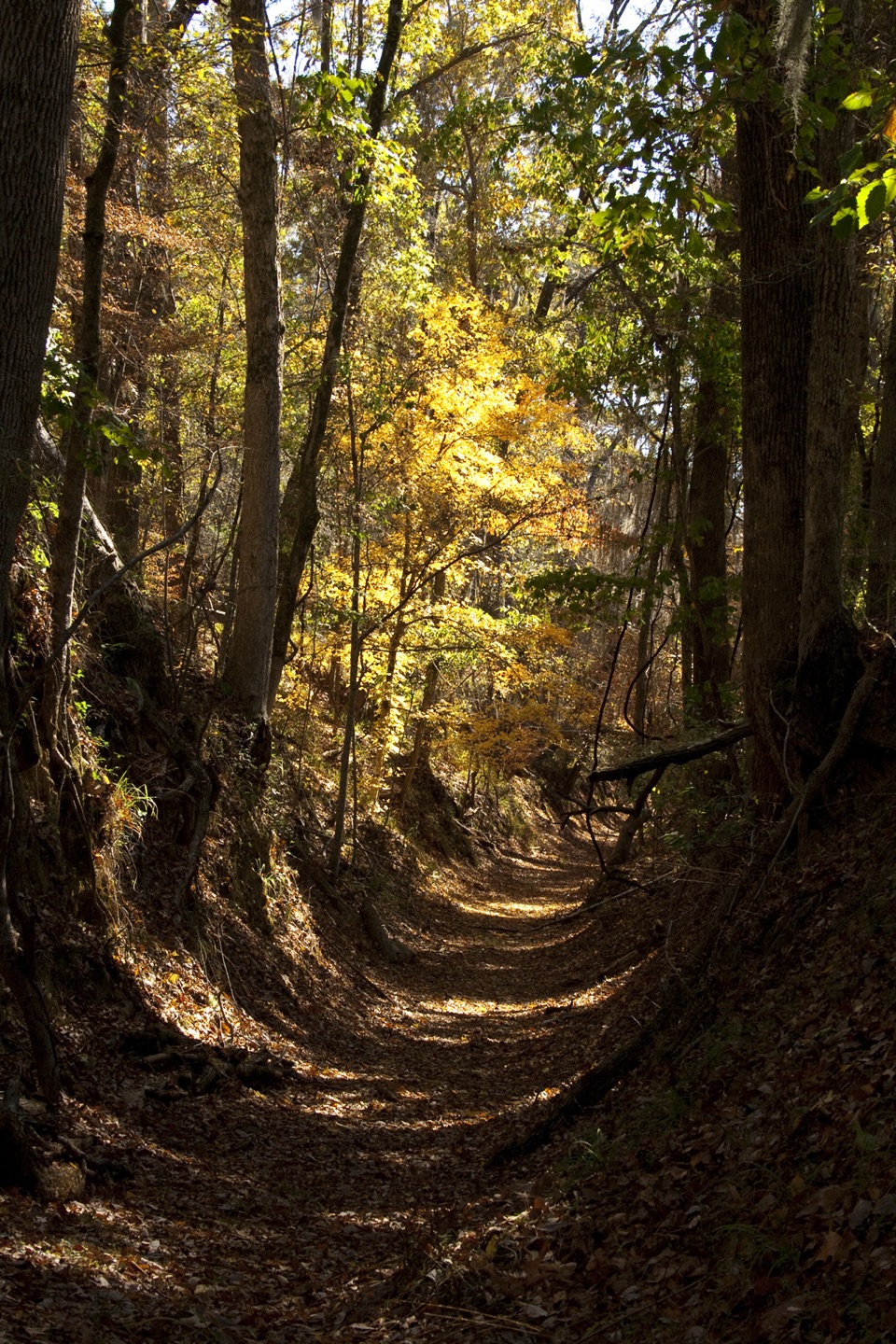
Potkopinu Section of the Natchez Trace National Scenic Trail in Natchez Trace Parkway

#4 of 26 trails in Natchez Trace

Natchez Trace Parkway, MS · AL · TN

Potkopinu Section of the Natchez Trace National Scenic Trail

Walk the longest remaining sunken stretch of the Old Trace

Photo: National Park Service
Length
3.4mi
Time
1.8hr
Elev. change
133ft
Difficulty
Moderate
  • Dogs allowed
  • High point 272 ft

Hear the audio tour

Potkopinu Section and Coles Creek

Overview

About Potkopinu Section of the Natchez Trace National Scenic Trail

Why go

  • Walk the original Natchez Trace through deeply eroded banks
  • The north end shows the sunken roadbed at its most visible

Heads up

  • Point-to-point logistics require a shuttle or retracing
  • Unbridged creek crossings can be muddy or knee-deep after rain
  • The south lot holds only a few cars and has no overflow

Map & elevation

The route

Loading the Natchez Trace map
Full map
Elevation139–272 ft
TrailheadSouth Potkopinu Trailhead (MP 17)31.70536, -91.17737
Keep this map with you offline in the Parkwolf app

Plan your hike

Before you go

Parking

At milepost 17, follow the signed dirt access road about a quarter-mile to the South Potkopinu lot, then use the short connector to the Trace. The lot fits only a few cars, has no overflow, and is not recommended for RVs. The north terminus is near milepost 20, reached from MS 553, and has the larger lot. Arrange a pickup there for the full one-way route.


Safety

Several creek crossings have no bridges and can be muddy or knee-deep after rain. Stay on the trail because the surrounding land is private. Horses are prohibited.

4 active Natchez Trace alerts

  • ClosureParkway sections closed for bridge and road constructionTwo Natchez Trace Parkway sections are closed to through traffic; follow the signed detours.Official details
  • ClosureMount Locust historic stand closedThe historic stand at Mount Locust Inn & Plantation (MP 15.5) is closed because of structural concerns.Official details
See all 4 alerts
A park ranger sits on a dash-mounted phone, talking, as Parkwolf’s Tour Guide plays “Army Cutworm Moths: A Grizzly Bear Buffet” on Grand Loop Road below Dunraven Pass in Yellowstone
Parkwolf Tour GuideThe highest, rockiest slopes around here are a summer buffet for grizzly bears.

Natchez Trace Tour Guide

Your drive to Potkopinu Section of the Natchez Trace National Scenic Trail, narrated.

Parkwolf is a GPS audio tour guide for Natchez Trace Parkway. As you drive, it chimes in with what’s ahead: hidden gems, upcoming stops, history, geology, and wildlife, right through your car’s speakers.

Recorded for this trailhead

Potkopinu Section and Coles Creek
0:00 / 0:25
“You're approaching the turnoff for the south Potkopinu trailhead. This is the longest walkable stretch of the original Trace, with banks more than twenty feet high where traffic wore the road down.”

Plays as you drive up to this trailhead in the Parkwolf Natchez Trace Tour Guide.

More stories near here in the app

  • Mount Locust Historic House
  • The Mud Chimney's Tenant
  • The Daytime Chorus
  • The Word on the Trail Sign
  • 272 audio storiesacross Natchez Trace’s roads, triggered by GPS as you drive
  • Wildlife heatmapsfor American Alligator, White-tailed Deer, Wild Turkey, and 9 more
  • Works offlinemaps, 26 trails, 62 places, and audio download before you lose signal
  • CarPlay readysimple controls built for the drive
★★★★★
“Fantastic app with many points of information… It’s great to just turn on while you’re driving and it gives you an audio tour of the national Park. We love it!!!!”
JMJamesApp Store review
Download Parkwolf on the App StoreGet Parkwolf on Google Play

4.7 from 8,600+ ratings

Trail guide

Hiking Potkopinu Section of the Natchez Trace National Scenic Trail

Walk the old TraceThe Potkopinu Section is a 3.

The Potkopinu Section is a 3.38-mile one-way trail between mileposts 17 and 20 on the Natchez Trace Parkway. It follows the longest surviving walkable stretch of the old Natchez Trace, where centuries of traffic cut a low roadbed into the hills. This is a point-to-point history walk, not a loop: arrange a pickup at the far end or turn back on the same trail. Walking it both ways makes an outing of about 6.8 miles. Plan roughly 1.5 to 2 hours one way, with extra time if water is over the crossings.

What the route preservesPotkopinu means “little valley” in the Natchez language.

Potkopinu means “little valley” in the Natchez language. The trail follows the original Trace for its full length. Its fine-grained soil erodes readily, and repeated passage by people, wagons and animals carved the old road into a sunken corridor. Some banks stand more than twenty feet above the tread, though the whole route is not walled in like a trench. The route threads through rolling ground east of the Parkway, with the southern mile described as relatively level and easy to follow. The deeper cut banks are the distinctive feature to watch for; toward the north end, the old road is at its most visible. A view along the worn corridor makes the clearest photo; stay on the path because the surrounding land is private.

Footing and waterThis is a natural dirt path, not a surfaced walking trail.

This is a natural dirt path, not a surfaced walking trail. The main physical complication is the water: several small creeks cross the route without bridges. Their crossings can be muddy or, after rain, knee-deep, so the walk may be slower than the mileage suggests. The route rises and falls rather than holding one long climb; it is a manageable distance, but wet crossings change the effort. Exact crossing locations are not established, so do not count on being able to avoid a wet one. Dogs are permitted on a leash no longer than six feet; horses are not permitted. Camping along this section or at its trailheads is prohibited without an advance special-use permit.

Access and logisticsThe south start is at South Potkopinu Trailhead near milepost 17.

The south start is at South Potkopinu Trailhead near milepost 17. Follow the signed dirt access road about a quarter-mile to a small lot, then take the short connector to the historic path. The lot fits only a few cars, has no overflow, and is not recommended for RVs. The north terminus near milepost 20 has the larger parking area and is reached from MS 553. For the full point-to-point walk, leave a vehicle there or arrange a ride; no reliable walking connection along the Parkway between ends was established. Neither trailhead listing describes food, restrooms or drinking water, so start prepared. No trail-specific fee or reservation is required, though a Parkway entrance fee may apply.

Wildlife

Wildlife in Natchez Trace

All Natchez Trace wildlife maps

Sighting maps show where each species has been reported across Natchez Trace. Wildlife moves, so no sighting is guaranteed.

Parkwolf’s Natchez Trace ranking

Top-rated trails in Natchez Trace

All 26 trails
  1. 1Cypress Swamp WalkEasy · 0.4 mi
  2. 2Jackson Falls TrailModerate · 0.4 mi
  3. 3Fall Hollow Waterfall TrailEasy · 0.2 mi
  4. 5Devil's Backbone TrailModerate · 3.1 mi
  5. 6Little Mountain TrailModerate · 1.7 mi
  6. 7Old Natchez Trace: War of 1812 Memorial to Garrison CreekEasy · 1.7 mi

Take Parkwolf to Natchez Trace.

The audio tour guide for the drive, plus offline maps, trails, and wildlife heatmaps for when the signal drops.

4.7 from 8,600+ ratings

Download Parkwolf on the App StoreGet Parkwolf on Google Play