Glen Tilt Through-Walk in Cairngorms National Park

Cairngorms National Park, SC

Glen Tilt Through-Walk

A remote 21-mile crossing with a serious river ford

Length
33.8km
Time
10hr
Elev. change
297m
Difficulty
Challenging
  • Dogs allowed
  • High point 490 m
  • #69 of 260 in Cairngorms

Hear the audio tour

Linn of Dee and the Gorge

Overview

About Glen Tilt Through-Walk

Why go

  • A full glen crossing links open Cairngorm uplands with the lower Tilt valley.
  • The Falls of Tarf and an 1886 memorial footbridge make a memorable landmark.

Heads up

  • The unbridged Geldie ford can make the route unsafe after heavy rain.
  • The 21-mile point-to-point needs a full day and a transport plan.

Map & elevation

The route

Loading the Cairngorms map
Full map
Elevation193–490 m
TrailheadLinn of Dee car park56.98956, -3.54344
Keep this map with you offline in the Parkwolf app

Plan your hike

Before you go

Parking

Start at Linn of Dee car park near Braemar; the mapped route begins about 200 m from the car-park pin. The crossing finishes at Fenderbridge in Blair Atholl, so arrange onward transport before setting off. Parking fee and capacity were not confirmed.

Safety

The Geldie Burn is unbridged and can rise quickly after heavy rain; cross only when it is plainly safe. Bynack Lodge is a dangerous ruin; keep clear.

3 active Cairngorms alerts

  • CautionStorm Boelo high windsStorm Boelo will bring extremely windy weather to the Cairngorms; take extra care and limit time outdoors. - The Park Authority expects the very windy weather to last until Monday 26 October.Official details
  • ClosureGlenmore wildfire closures and dangerous treesWildfire damage has closed Allt Mor car park and the path to Sugarbowl/Utsi’s Bridge; keep out of the closed area.Official details
See all 3 alerts
A park ranger sits on a dash-mounted phone, talking, as Parkwolf’s Tour Guide plays “Army Cutworm Moths: A Grizzly Bear Buffet” on Grand Loop Road below Dunraven Pass in Yellowstone
Parkwolf Tour GuideThe highest, rockiest slopes around here are a summer buffet for grizzly bears.

Cairngorms Tour Guide

Your drive to Glen Tilt Through-Walk, narrated.

Parkwolf is a GPS audio tour guide for Cairngorms National Park. As you drive, it chimes in with what’s ahead: hidden gems, upcoming stops, history, geology, and wildlife, right through your car’s speakers.

See the Cairngorms audio tour

Recorded for this trailhead

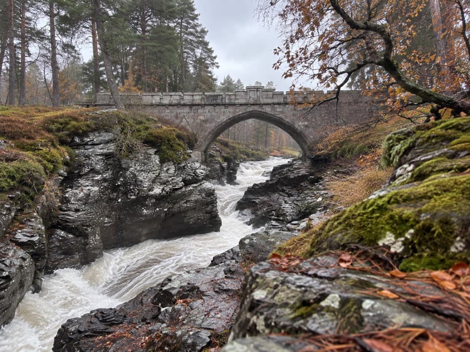
Linn of Dee and the Gorge
0:00 / 0:30
“You're approaching Linn of Dee, where the river squeezes through a narrow rocky gorge beneath a granite bridge. This is worth a short stop even if you're not heading into the mountains.”

Plays as you drive up to this trailhead in the Parkwolf Cairngorms Tour Guide.

More stories near here in the app

  • Creag Bhalg from Claybokie
  • The Colonel’s Bed from Meikle Inverey
  • The Ants’ Sugary Supply
  • Linn of Quoich and the Punchbowl
  • 298 audio storiesacross Cairngorms’s roads, triggered by GPS as you drive
  • Wildlife heatmapsfor Red Deer, Reindeer, Osprey, and 13 more
  • Works offlinemaps, 260 trails, 90 places, and audio download before you lose signal
  • CarPlay readysimple controls built for the drive
★★★★★
“Fantastic app with many points of information… It’s great to just turn on while you’re driving and it gives you an audio tour of the national Park. We love it!!!!”
JMJamesApp Store review
Download Parkwolf on the App StoreGet Parkwolf on Google Play

4.7 from 8,600+ ratings

Trail guide

Hiking Glen Tilt Through-Walk

What this route isGlen Tilt Through-Walk is a 21-mile, one-way crossing from Linn of Dee to Fenderbridge in Blair…

Glen Tilt Through-Walk is a 21-mile, one-way crossing from Linn of Dee to Fenderbridge in Blair Atholl. It follows the Dee and Geldie, crosses the watershed by Bynack Lodge, then descends past the Falls of Tarf into the lower Tilt valley. The appeal is the whole change of country, not a short visit to the waterfall.

Plan for a full dayAllow roughly 10 hours on foot as a planning estimate; no standard time is published.

Allow roughly 10 hours on foot as a planning estimate; no standard time is published. This is a remote point-to-point route, not a loop, so arrange transport from the Blair Atholl end before setting out. No reliable food, toilet or water stops were verified along the way, so carry what you need for the full crossing.

The Geldie is the key decisionThe estate track from Linn of Dee leads toward the Geldie Burn, where the old bridge is gone…

The estate track from Linn of Dee leads toward the Geldie Burn, where the old bridge is gone and the route requires a serious ford. The water can rise quickly after heavy rain. Do not attempt a crossing that is not plainly safe; be ready to turn back or choose another walk.

Across the watershedAfter the Geldie, the track gets rougher and passes the Bynack Lodge ruins.

After the Geldie, the track gets rougher and passes the Bynack Lodge ruins. About a kilometre of track gives way to footpath toward the watershed. The route then follows a clear path south of Bedford Memorial Bridge at the Falls of Tarf.

Down to Blair AthollFrom the Falls of Tarf, the way follows estate track to Auchgobhal, grassy track to Kincraigie…

From the Falls of Tarf, the way follows estate track to Auchgobhal, grassy track to Kincraigie farm, then farm and public roads to Blair Atholl. Expect the surface to change repeatedly from track to rough path and road; the full crossing is a substantial walk even without the ford.

A bridge with a hard historyBedford Memorial Bridge commemorates Francis John Bedford, who drowned while trying to ford the…

Bedford Memorial Bridge commemorates Francis John Bedford, who drowned while trying to ford the Tarf in 1879, aged 18. The bridge was erected in 1886. The falls and footbridge make a distinctive mid-route pause, but the bridge story also underlines why a river crossing deserves respect.

The route and Scotland’s access rightsGlen Tilt is a public right of way.

Glen Tilt is a public right of way. In 1847, botanist John Hutton Balfour and students challenged an attempt to keep walkers out; the dispute reached the House of Lords and affirmed the right of way. Dogs may accompany walkers under Scotland’s responsible-access rules; keep them under proper control.

Hutton’s geological evidenceGlen Tilt’s geology helped James Hutton make an early case for Plutonism.

Glen Tilt’s geology helped James Hutton make an early case for Plutonism. His 1785 observations supported the idea that molten rock and other natural processes shape the landscape over immense spans of time.

Wildlife

Wildlife in Cairngorms

All Cairngorms wildlife maps

Sighting maps show where each species has been reported across Cairngorms. Wildlife moves, so no sighting is guaranteed.

Keep exploring

Near Glen Tilt Through-Walk

See it all on the map

Trails that start nearby

Places near the trailhead

Parkwolf’s Cairngorms ranking

Top-rated trails in Cairngorms

All 260 trails
  1. 1Loch an Eilein CircuitEasy · 5 km
  2. 2Lairig GhruChallenging · 30.6 km
  3. 3Ben Macdui and Cairn Gorm CircuitChallenging · 19.8 km
  4. 4Loch Morlich TrailModerate · 5.6 km
  5. 5Meall a’ Bhuachaille CircuitChallenging · 8 km
  6. 6Loch Muick CircuitModerate · 12.5 km

Take Parkwolf to Cairngorms.

The audio tour guide for the drive, plus offline maps, trails, and wildlife heatmaps for when the signal drops.

4.7 from 8,600+ ratings

Download Parkwolf on the App StoreGet Parkwolf on Google Play