Horseshoe Canyon Trail to the Great Gallery in Canyonlands National Park

#5 of 63 trails in Canyonlands

Canyonlands National Park, UT

Horseshoe Canyon Trail to the Great Gallery

Life-sized rock art awaits after a sandy canyon walk and steep climb.

Photo: Wikimedia Commons
Length
7mi
Time
5.5hr
Elev. change
617ft
Difficulty
Challenging
  • No dogs
  • High point 5,328 ft

Hear the audio tour

Horseshoe Canyon and the Great Gallery

Overview

About Horseshoe Canyon Trail to the Great Gallery

Why go

  • Several distinct rock-art panels lead to the Great Gallery.
  • Cottonwoods and the dinosaur track break up the long canyon walk.

Heads up

  • The 780-foot descent becomes a steep climb on the way out.
  • Soft sand, little reliable water, and a remote dirt-road approach make this a demanding day.

Map & elevation

The route

Loading the Canyonlands map
Full map
Elevation4,711–5,328 ft
TrailheadHorseshoe Canyon West Rim Trailhead38.47383, -110.20040
Keep this map with you offline in the Parkwolf app

Plan your hike

Before you go

Parking

Start at Horseshoe Canyon West Rim Trailhead. The approach from UT-24 is roughly 30 miles of graded dirt road; weather can change conditions quickly, so check the current park road report before driving. There is a vault toilet at the rim and primitive camping on adjacent BLM land, but no water.

Best time to go

Spring and fall bring more moderate temperatures, and the canyon's exposed stretches make heat a real factor. Carry about 4 liters of water per person, plus lunch; there is no water at the rim and water in the canyon is unreliable. At the Great Gallery, step back far enough to show the length of the painted wall against its sandstone alcove. The panel gets morning light and afternoon shade, so the light changes how the figures stand out.

Safety

The steep 780-foot descent is also the climb out. Uneven rock, soft sand, heat, and the long distance make this strenuous. Carry about 4 liters of water per person; there is no water above the rim and canyon sources are unreliable. Dogs are prohibited below the rim.

2 active Canyonlands alerts

  • ClosureRain-damaged Needles backcountry roads impassableRecent rains have made several Needles backcountry roads impassable; do not drive these routes.Official details
  • CautionMaze access roads require high-clearance 4WDOnly use high-clearance 4WD to reach Hans Flat or Horseshoe Canyon in The Maze; low-clearance vehicles are not recommended on these damaged, rutted, muddy routes.Official details
Canyonlands alerts
A park ranger sits on a dash-mounted phone, talking, as Parkwolf’s Tour Guide plays “Army Cutworm Moths: A Grizzly Bear Buffet” on Grand Loop Road below Dunraven Pass in Yellowstone
Parkwolf Tour GuideThe highest, rockiest slopes around here are a summer buffet for grizzly bears.

Canyonlands Tour Guide

Your drive to Horseshoe Canyon Trail to the Great Gallery, narrated.

Parkwolf is a GPS audio tour guide for Canyonlands National Park. As you drive, it chimes in with what’s ahead: hidden gems, upcoming stops, history, geology, and wildlife, right through your car’s speakers.

See the Canyonlands audio tour

Recorded for this trailhead

Horseshoe Canyon and the Great Gallery
0:00 / 0:28
“You're approaching the west-rim trailhead for Horseshoe Canyon, where the Great Gallery's life-size painted figures are reached on foot.”

Plays as you drive up to this trailhead in the Parkwolf Canyonlands Tour Guide.

More stories near here in the app

  • Food and Tools in a Leather Bag
  • 43 audio storiesacross Canyonlands’s roads, triggered by GPS as you drive
  • Wildlife heatmapsfor Bighorn Sheep, Mule Deer, Coyote, and 13 more
  • Works offlinemaps, 63 trails, 65 places, and audio download before you lose signal
  • CarPlay readysimple controls built for the drive
★★★★★
“Fantastic app with many points of information… It’s great to just turn on while you’re driving and it gives you an audio tour of the national Park. We love it!!!!”
JMJamesApp Store review
Download Parkwolf on the App StoreGet Parkwolf on Google Play

4.7 from 8,600+ ratings

Trail guide

Hiking Horseshoe Canyon Trail to the Great Gallery

The long walk to the Great GalleryHorseshoe Canyon Trail to the Great Gallery is a remote 7-mile out-and-back from the west rim,…

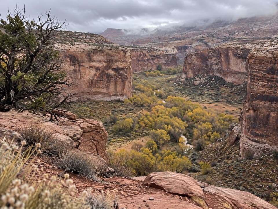
Horseshoe Canyon Trail to the Great Gallery is a remote 7-mile out-and-back from the west rim, down into a broad canyon and back up the same way. The Great Gallery is the payoff, but it is not the only stop: High, Horseshoe and Alcove panels appear along the canyon floor, and a dinosaur track sits beside the descent. Plan on five to six hours so you have time to look closely. The hike is strenuous less because of technical climbing than because it pairs a steep drop and climb with miles of soft sand.

Down the rim, then across the canyonThe route starts on an old four-wheel-drive road and loses about 780 feet on uneven, rocky…

The route starts on an old four-wheel-drive road and loses about 780 feet on uneven, rocky ground. The return climb is the same grade in reverse, so save energy for the end. Near a water tank on the descent, look along the edge of the trail for the dinosaur footprint; it is easy to walk past while watching your footing. At the bottom, the route turns up-canyon through sandy wash and patches of cottonwood beside an intermittent stream. The floor is gentler than the rim but can feel slow underfoot, and the stream is not a dependable water source.

The panels come in sequenceKeep an eye out for the smaller panels as you continue up-canyon: High, then Horseshoe, then…

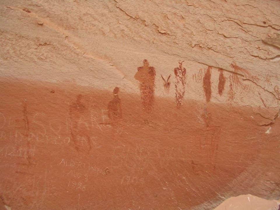
Keep an eye out for the smaller panels as you continue up-canyon: High, then Horseshoe, then Alcove, before the Great Gallery. They are part of this hike, not separate trail destinations. It is possible to pass a panel while following the wash, so carry a map and retrace a short stretch if the landmarks stop matching. The Great Gallery is a long wall of painted figures, including life-sized forms and intricate designs. Give yourself time to take in the whole wall and then notice the details; this is a place to look carefully, not hurry to a turnaround and leave.

What the canyon preservesThe paintings are examples of Barrier Canyon style rock art.

The paintings are examples of Barrier Canyon style rock art. The National Park Service describes the Great Gallery as one of North America's most significant ancient rock-marking sites. Canyonlands added Horseshoe Canyon to the park in 1971 to protect the art. The images have been studied and documented, but their precise meaning is not something a visitor can settle from a quick look; let the figures speak for themselves, and do not touch them. The route also passes cottonwood groves along the seasonal stream, with spring wildflowers reported in the canyon.

The remote approach is part of the dayThe west-rim trailhead is reached by roughly 30 miles of graded dirt road from UT-24.

The west-rim trailhead is reached by roughly 30 miles of graded dirt road from UT-24. Rain and other weather can change the road quickly, so check the current park road report before driving; the approach can require a high-clearance vehicle when conditions deteriorate. A vault toilet is available at the rim, and primitive camping is on adjacent BLM land; there is no water or food service. Do not plan to camp overnight in the national park section of the canyon. Dogs are prohibited below the rim, and the National Park Service limits hiking groups to 20 people.

Wildlife

Wildlife in Canyonlands

All Canyonlands wildlife maps

Sighting maps show where each species has been reported across Canyonlands. Wildlife moves, so no sighting is guaranteed.

Parkwolf’s Canyonlands ranking

Top-rated trails in Canyonlands

All 63 trails
  1. 1Mesa Arch TrailEasy · 0.6 mi
  2. 2Chesler Park Loop and Joint TrailChallenging · 10.7 mi
  3. 3Druid Arch TrailChallenging · 10.8 mi
  4. 4Grand View Point TrailEasy · 1.8 mi
  5. 6White Rim Overlook TrailEasy · 1.8 mi
  6. 7Chesler Park Viewpoint TrailChallenging · 5.8 mi

Take Parkwolf to Canyonlands.

The audio tour guide for the drive, plus offline maps, trails, and wildlife heatmaps for when the signal drops.

4.7 from 8,600+ ratings

Download Parkwolf on the App StoreGet Parkwolf on Google Play