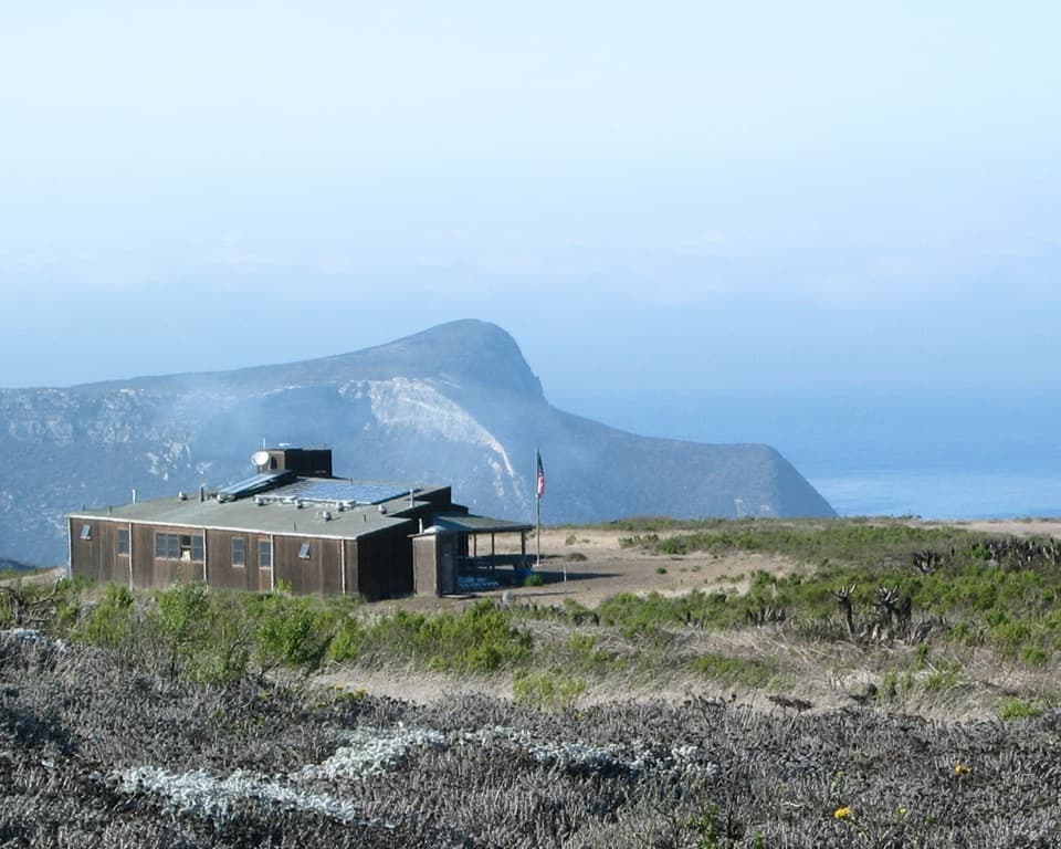
San Miguel Island Ranger and Visitor Contact Station in Channel Islands National Park

Ranger station · Channel Islands National Park

San Miguel Island Ranger and Visitor Contact Station

A working ranger outpost on an island that requires a permit.

Photo: Derek Lohuis / National Park Service

Type
Ranger station
Nearest trail
0.3 mi
  • Restrooms

Overview

About San Miguel Island Ranger and Visitor Contact Station

Why stop

  • A rare look at the working ranger outpost behind the island’s visitor program.

Heads up

  • A permit and one-mile walk from Cuyler Harbor make this a side stop.

Map

Where it is

Loading the Channel Islands map
Full map
Ranger stationSan Miguel Island Ranger and Visitor Contact Station34.03854, -120.35156
Keep this map with you offline in the Parkwolf app

Plan your stop

Before you go

2 active Channel Islands alerts

  • ClosureSanta Rosa Island wildfire-recovery closuresBurned areas on Santa Rosa Island remain closed during wildfire recovery, and Southeast Quadrant backcountry beach camping is closed for the remainder of the 2026 recreation season.Official details
  • InfoSanta Barbara Island dock closed; landings restrictedThe Santa Barbara Island dock is closed; land only on the adjacent rocky ledge.Official details

Channel Islands alerts
A park ranger sits on a dash-mounted phone, talking, as Parkwolf’s Tour Guide plays “Army Cutworm Moths: A Grizzly Bear Buffet” on Grand Loop Road below Dunraven Pass in Yellowstone
Parkwolf Tour GuideThe highest, rockiest slopes around here are a summer buffet for grizzly bears.

Channel Islands Tour Guide

Your drive to San Miguel Island Ranger and Visitor Contact Station, narrated.

Parkwolf is a GPS audio tour guide for Channel Islands National Park. As you drive, it chimes in with what’s ahead: hidden gems, upcoming stops, history, geology, and wildlife, right through your car’s speakers.

See the Channel Islands audio tour
  • 16 audio storiesacross Channel Islands’s roads, triggered by GPS as you drive
  • Wildlife heatmapsfor Island Fox, Humpback Whale, Blue Whale, and 13 more
  • Works offlinemaps, 48 trails, 75 places, and audio download before you lose signal
  • CarPlay readysimple controls built for the drive
★★★★★
“Fantastic app with many points of information… It’s great to just turn on while you’re driving and it gives you an audio tour of the national Park. We love it!!!!”
JMJamesApp Store review
Download Parkwolf on the App StoreGet Parkwolf on Google Play

4.7 from 8,600+ ratings

Guide

More about San Miguel Island Ranger and Visitor Contact Station

A working station at the end of the landing stripSan Miguel Island Ranger and Visitor Contact Station is a low, one-story National Park Service…

San Miguel Island Ranger and Visitor Contact Station is a low, one-story National Park Service building at the west end of the landing strip. It brings the island ranger’s home and office together with a bunkhouse for visiting researchers. This is a working outpost, not a conventional visitor center. The station is about a mile from the Cuyler Harbor landing, along the designated trail.

Make it part of a planned island visitSan Miguel is a Navy-owned island with permit-only access, and the island is open to visitors…

San Miguel is a Navy-owned island with permit-only access, and the island is open to visitors only when NPS personnel are there. You can walk from Cuyler Harbor to the station without a ranger, but going farther requires a ranger or park staff member with you. Stay on designated trails; off-trail hiking is prohibited. There are no shops, food, lodging, or visitor water on the island, so bring what you need. A pit toilet is listed close to the station.

From a canyon tent to the mesaThe island’s ranger post began in Nidever Canyon.

The island’s ranger post began in Nidever Canyon. A 1976 agreement let the National Park Service manage the island and run a tightly controlled visitor program while the Navy kept legal possession. By 1978, visitors could contact a ranger at a tent near the old windmill; the ranger accompanied people beyond that area along a road built during World War II. The tent gave way to a shipping container in the 1980s.

Built for the islandThe current station went up on the mesa in 1997.

The current station went up on the mesa in 1997. Its design echoes the lines of the Lester ranch house, and one building now combines the ranger’s residence, the contact office, and a researcher bunkhouse. It runs on solar power and draws water from a well in Nidever Canyon, but that water isn’t available to visitors.

Wildlife

Wildlife in Channel Islands

All Channel Islands wildlife maps

Sighting maps show where each species has been reported across Channel Islands. Wildlife moves, so no sighting is guaranteed.

Keep exploring

Near San Miguel Island Ranger and Visitor Contact Station

See it all on the map

Trails nearby

More stops nearby

Parkwolf’s Channel Islands ranking

Top sights in Channel Islands

All 75 places
  1. 1Inspiration PointSight
  2. 2Scorpion Anchorage and BeachBeach
  3. 3Arch RockSight
  4. 4Potato Harbor OverlookSight
  5. 5Painted CaveSight
  6. 6Cavern PointSight

Take Parkwolf to Channel Islands.

The audio tour guide for the drive, plus offline maps, trails, and wildlife heatmaps for when the signal drops.

4.7 from 8,600+ ratings

Download Parkwolf on the App StoreGet Parkwolf on Google Play