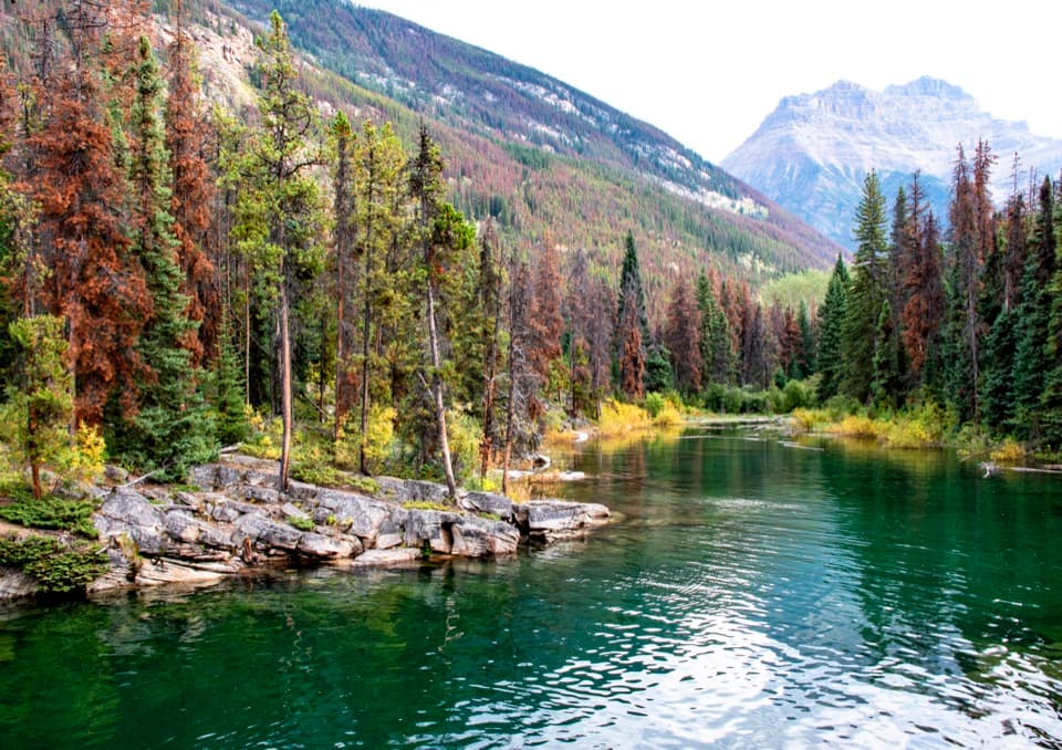
Horseshoe Lake Trail in Icefields Parkway (Highway 93)

Icefields Parkway (Highway 93), AB

Horseshoe Lake Trail

A short loop for clear water and cliff-framed lake views.

Photo: Wikimedia Commons
Length
1.6km
Time
30min
Elev. change
15m
Difficulty
Easy
  • Loop
  • Dogs allowed
  • High point 1,258 m

Hear the audio tour

Horseshoe Lake: Clear Water and Cliff Views

Overview

About Horseshoe Lake Trail

Why go

  • Clear water and cliff views on a half-hour walk
  • Several shoreline viewpoints make the short route feel like a real hike

Heads up

  • Rooty tread and faint side paths at a few junctions
  • Unprotected cliff edges need close attention

Map & elevation

The route

Loading the Icefields Parkway map
Full map
Elevation1,243–1,258 m
TrailheadHorseshoe Lake Parking Lot52.69481, -117.86714
Keep this map with you offline in the Parkwolf app

Plan your hike

Before you go

Parking

From Jasper, drive south on the Icefields Parkway (93N) about 16.2 miles (26 km) beyond the junction, then turn left into the small Horseshoe Lake roadside pullout. The highway sign has been removed, so use a map and watch the odometer. Capacity and parking fees were not verified.

Safety

The trail passes close to steep, unguarded cliffs above cold water. Stay back from the edges and do not cliff jump. Rooty footing and several faint path choices call for attention at junctions.

2 active Icefields Parkway alerts

  • ClosureWildfire-impacted area closures in JasperStay out of the closed wildfire-impacted areas in Jasper National Park; access is prohibited or restricted to protect public safety.Official details
  • ClosureOpal Hills hiking area closed for grizzly bearThe Opal Hills hiking area is closed because a female grizzly bear with two offspring is in the area. - The closure took effect September 25, 2026, and remains in effect until further notice.Official details
Icefields Parkway alerts
A park ranger sits on a dash-mounted phone, talking, as Parkwolf’s Tour Guide plays “Army Cutworm Moths: A Grizzly Bear Buffet” on Grand Loop Road below Dunraven Pass in Yellowstone
Parkwolf Tour GuideThe highest, rockiest slopes around here are a summer buffet for grizzly bears.

Icefields Parkway Tour Guide

Your drive to Horseshoe Lake Trail, narrated.

Parkwolf is a GPS audio tour guide for Icefields Parkway (Highway 93). As you drive, it chimes in with what’s ahead: hidden gems, upcoming stops, history, geology, and wildlife, right through your car’s speakers.

See the Icefields Parkway audio tour

Recorded for this trailhead

Horseshoe Lake: Clear Water and Cliff Views
0:00 / 0:24
“Horseshoe Lake is coming up, a good stop for clear water tucked beneath steep rock walls.”

Plays as you drive up to this trailhead in the Parkwolf Icefields Parkway Tour Guide.

More stories near here in the app

  • Why Jasper Is Called Jasper
  • Chipmunk or Ground Squirrel?
  • The Meadow an Avalanche Keeps Open
  • Athabasca Falls: Follow the Canyon
  • 141 audio storiesacross Icefields Parkway’s roads, triggered by GPS as you drive
  • Wildlife heatmapsfor Grizzly Bear, Black Bear, Moose, and 13 more
  • Works offlinemaps, 54 trails, 57 places, and audio download before you lose signal
  • CarPlay readysimple controls built for the drive
★★★★★
“Fantastic app with many points of information… It’s great to just turn on while you’re driving and it gives you an audio tour of the national Park. We love it!!!!”
JMJamesApp Store review
Download Parkwolf on the App StoreGet Parkwolf on Google Play

4.7 from 8,600+ ratings

Trail guide

Hiking Horseshoe Lake Trail

The one-mile walkHorseshoe Lake Trail is an easy lollipop loop from a roadside pullout on the Icefields Parkway.

Horseshoe Lake Trail is an easy lollipop loop from a roadside pullout on the Icefields Parkway. It is about 1.0 mile (1.6 km) with a short approach, the lakeside circuit and two small viewpoint detours; allow about half an hour. The route visits only part of the horseshoe-shaped shore, not the whole lake. It is a good leg-stretch for clear water and cliff views, not a long hike.

Follow the forksA dirt path leaves the lot and reaches a junction after roughly a tenth of a mile.

A dirt path leaves the lot and reaches a junction after roughly a tenth of a mile. The left branch makes a quick out-and-back along the cliffs; return to the fork, then take the lake-bound path. Small footbridges and a couple of short viewpoint spurs break up the shore walk. Roots make the tread uneven, and several faint side paths can be easy to confuse, so follow the main loop rather than wandering every branch.

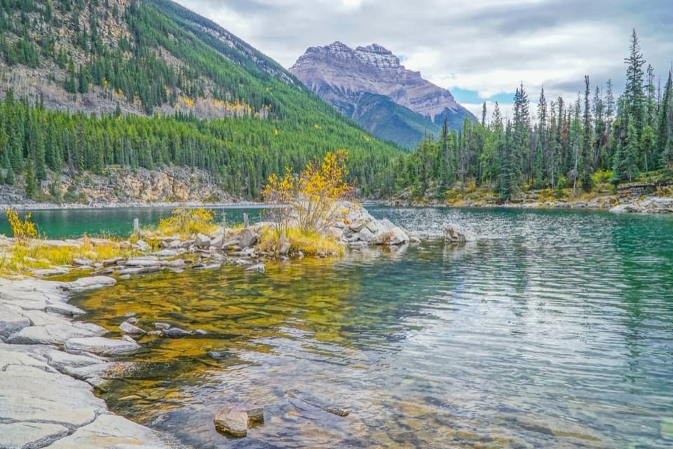
At the waterClear blue-green water sits beneath steep rock walls, with little coves and places to pause by…

Clear blue-green water sits beneath steep rock walls, with little coves and places to pause by the shore. The water stays cold even in summer. Parts of the path run close to unguarded cliffs, so keep back from the edge; Parks Canada warns against cliff jumping at the lake.

A fire-scarred shoreThe 2024 Jasper wildfire changed the woods around Horseshoe Lake.

The 2024 Jasper wildfire changed the woods around Horseshoe Lake. Visitors in recent years describe scorched trees and fallen wood beside young regrowth. The main photo shows the cove in September 2019, before that fire, so the tree cover in the image is older than the current landscape.

Getting thereFrom Jasper, take the Icefields Parkway (93N) south about 16.

From Jasper, take the Icefields Parkway (93N) south about 16.2 miles (26 km) past the junction, then turn left into the small Horseshoe Lake pullout. The highway sign has been removed; use a map and watch your odometer. Dogs are allowed on leash. No food service or potable water was verified at the trailhead, so bring what you need.

Wildlife

Wildlife in Icefields Parkway

All Icefields Parkway wildlife maps

Sighting maps show where each species has been reported across Icefields Parkway. Wildlife moves, so no sighting is guaranteed.

Keep exploring

Near Horseshoe Lake Trail

See it all on the map

Trails that start nearby

Places near the trailhead

Parkwolf’s Icefields Parkway ranking

Top-rated trails in Icefields Parkway

All 54 trails
  1. 1Parker Ridge TrailModerate · 5.6 km
  2. 2Peyto Lake Lookout TrailEasy · 1.2 km
  3. 3Wilcox PassModerate · 6.8 km
  4. 4Bow Glacier Falls TrailModerate · 9.1 km
  5. 5Helen Lake TrailModerate · 11.8 km
  6. 6Path of the Glacier TrailModerate · 1.6 km

Take Parkwolf to Icefields Parkway.

The audio tour guide for the drive, plus offline maps, trails, and wildlife heatmaps for when the signal drops.

4.7 from 8,600+ ratings

Download Parkwolf on the App StoreGet Parkwolf on Google Play