Brant Fell above Bowness-on-Windermere in Lake District National Park

Lake District National Park, EN

Brant Fell above Bowness-on-Windermere

A steep 2.1 mile loop from Bowness to big Windermere views

Photo: Wikimedia Commons
Length
3.4km
Time
1.8hr
Elev. change
123m
Difficulty
Moderate
  • Loop
  • Dogs allowed
  • High point 174 m

Hear the audio tour

Bowness: Beatrix Potter or Brant Fell

Overview

About Brant Fell above Bowness-on-Windermere

Why go

  • Big Windermere views from a short town-centre climb
  • Distinctive summit gateposts and rocky outcrops

Heads up

  • Steep, muddy and more awkward underfoot than the mileage suggests
  • Town roads, gates and stiles dilute the fell experience
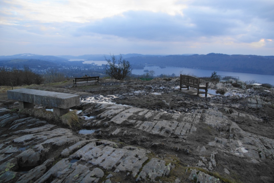
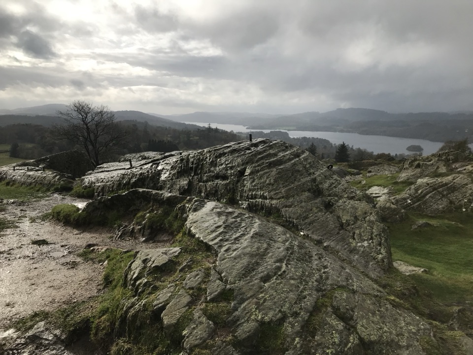
The summit is marked by two old stone gateposts and a cluster of large rocks, with open views over Windermere, the rooftops of Bowness, the Grizedale side and the surrounding fells. Those summit rocks have vertical faces of roughly 6 to 10 ft, so keep children and dogs close while you are scrambling about for a viewpoint. Early or late light can suit photography here, with the lake below and the fells beyond.
Parkwolf’s verdictThe payoff and the rock

Map & elevation

The route

Loading the Lake District map
Full map
Elevation51–174 m
TrailheadBowness-on-Windermere town-centre mini-roundabout54.36477, -2.91970
Keep this map with you offline in the Parkwolf app

Plan your hike

Before you go

Parking

Start at the Bowness-on-Windermere town-centre mini-roundabout where the A592 and A5074 meet, beside St Martins Church. Use a town car park such as Rayrigg Road or The Glebe, then walk to the start. Parking gets very busy on weekends and holidays.

Safety

The climb is steep and the route includes muddy lanes, rough rocky ground, grassy slopes, gates and stiles. The step-stile into the return lane is partly hidden and can be missed. Summit rocks have 6 to 10 ft vertical faces. Keep children and dogs supervised there, keep dogs on leads around livestock, and carry water because none is available on route. The upper section of Brantfell Road is private but public access is allowed.

8 active Lake District alerts

  • ClosureChapel Stile footpath closed for retaining-wall riskPart of Footpath 543030 between Chapel Stile and Baysbrown campsite is closed because a retaining wall beside the path could collapse and material it supports could fall across the footpath.Official details
  • ClosureStanley Ghyll Lower Falls footpath closed for rockfallThe section of Footpath 408037 leading towards Stanley Ghyll Lower Falls is closed because severe rockfall damage has made the path unstable and further rockfall remains a danger.Official details
See all 8 alerts
A park ranger sits on a dash-mounted phone, talking, as Parkwolf’s Tour Guide plays “Army Cutworm Moths: A Grizzly Bear Buffet” on Grand Loop Road below Dunraven Pass in Yellowstone
Parkwolf Tour GuideThe highest, rockiest slopes around here are a summer buffet for grizzly bears.

Lake District Tour Guide

Your drive to Brant Fell above Bowness-on-Windermere, narrated.

Parkwolf is a GPS audio tour guide for Lake District National Park. As you drive, it chimes in with what’s ahead: hidden gems, upcoming stops, history, geology, and wildlife, right through your car’s speakers.

Recorded for this trailhead

Bowness: Beatrix Potter or Brant Fell
0:00 / 1:18
“You're coming up on Bowness village, where you can step into Beatrix Potter's stories or climb above the rooftops on Brant Fell.”

Plays as you drive up to this trailhead in the Parkwolf Lake District Tour Guide.

More stories near here in the app

  • Windermere at Bowness
  • Windermere Jetty: Boats and Boatbuilders
  • Orrest Head: A Short Climb for the View
  • Claife Viewing Station: Colour and Shore
  • 298 audio storiesacross Lake District’s roads, triggered by GPS as you drive
  • Wildlife heatmapsfor Red Deer, Eurasian Otter, Osprey, and 13 more
  • Works offlinemaps, 265 trails, 89 places, and audio download before you lose signal
  • CarPlay readysimple controls built for the drive
★★★★★
“Fantastic app with many points of information… It’s great to just turn on while you’re driving and it gives you an audio tour of the national Park. We love it!!!!”
JMJamesApp Store review
Download Parkwolf on the App StoreGet Parkwolf on Google Play

4.7 from 8,600+ ratings

Trail guide

Hiking Brant Fell above Bowness-on-Windermere

The routeThis is a circular walk, 2.1 miles for the whole loop, with about 137 m of ascent.

This is a circular walk, 2.1 miles for the whole loop, with about 137 m of ascent. It starts and finishes at the town-centre mini-roundabout where the A592 and A5074 meet, beside St Martins Church. From there you climb Brantfell Road, cross a field and follow a fenced track up to Post Knott, then pass through gates and up steep grass among rocky outcrops to the summit of Brant Fell. The return turns sharply north, runs above a reservoir, drops through a partly hidden step-stile into a muddy lane, crosses a stone stile into a field, picks up the Dales Way back to the junction, and finishes on the road network and Helm Road.

How hard it isDifficulty 4 out of 10.

Difficulty 4 out of 10. It is short, but the climb is steep in places and the ground includes mud, rough rocky sections, grassy slopes, gates and stiles. Allow 1.5 to 2 hours with stops for photos and the summit. Surfaces shift from town pavement and road at each end to tracks, field paths, grass and rocky ground in the middle.

Footing and route-findingThe two things that catch people out are the steep grass among outcrops below the summit and…

The two things that catch people out are the steep grass among outcrops below the summit and the stiles on the return. The step-stile leading into the muddy lane is partly hidden, so slow down and look for it rather than pushing on along the fence line. Mud in that lane and in the field sections is a recurring feature rather than a one-off, and the grassy pull to the top is awkward when it is slick. Assume no water on the route and carry what you need.

Crowds, parking and accessPark in the Bowness town car parks, such as Rayrigg Road or The Glebe, then walk to the start.

Park in the Bowness town car parks, such as Rayrigg Road or The Glebe, then walk to the start. Town parking gets very busy at weekends and on holidays, so build in time for that. The route mixes town roads, a private upper stretch of Brantfell Road where public access is allowed, tracks, field paths, gates and stiles. Dogs can use the route under ordinary public-footpath access; keep them on leads anywhere livestock may be present, and supervised near the summit rocks.

Is it worth itFor a walk that starts at a roundabout in the middle of town, the height gain per mile is…

For a walk that starts at a roundabout in the middle of town, the height gain per mile is generous and the view from the top is far better than the distance suggests. The limits are honest ones: it is short, it never leaves earshot of the town for long, and the climbing and mud make it less casual than the mileage implies. Post Knott also exists as its own separate short, steep walk of about 1.5 miles with varied views; on this loop it is simply one stop on the way up to Brant Fell.

Wildlife

Wildlife in Lake District

All Lake District wildlife maps

Sighting maps show where each species has been reported across Lake District. Wildlife moves, so no sighting is guaranteed.

Keep exploring

Near Brant Fell above Bowness-on-Windermere

See it all on the map

Trails that start nearby

Places near the trailhead

Parkwolf’s Lake District ranking

Top-rated trails in Lake District

All 265 trails
  1. 1Scafell Pike via Hollow Stones from WasdaleChallenging · 9 km
  2. 2Helvellyn via Striding Edge and Swirral EdgeChallenging · 12.4 km
  3. 3CatbellsModerate · 6.6 km
  4. 4The Old Man of ConistonChallenging · 9 km
  5. 5Buttermere CircularEasy · 7.6 km
  6. 6The Fairfield HorseshoeChallenging · 17.2 km

Take Parkwolf to Lake District.

The audio tour guide for the drive, plus offline maps, trails, and wildlife heatmaps for when the signal drops.

4.7 from 8,600+ ratings

Download Parkwolf on the App StoreGet Parkwolf on Google Play