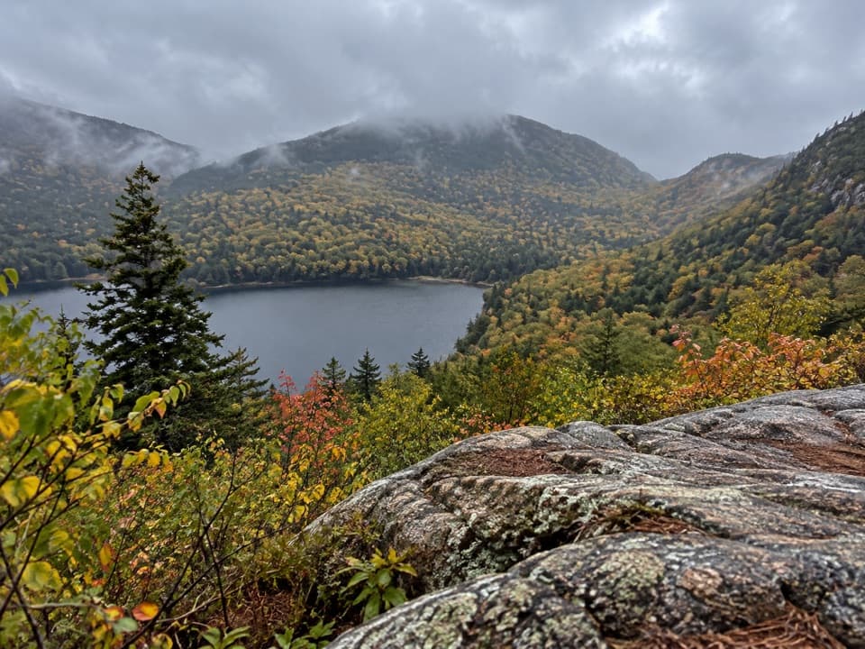
Conners Nubble Trail in Acadia National Park

Acadia National Park, ME

Conners Nubble Trail

A short granite climb to an open Eagle Lake view.

Length
0.3mi
Time
30min
Elev. change
52ft
Difficulty
Moderate
  • Dogs allowed
  • High point 525 ft

Hear the audio tour

Bubbles Divide and Bubble Rock

Overview

About Conners Nubble Trail

Why go

  • Open summit view over Eagle Lake and nearby peaks.

Heads up

  • The spur has no parking; reaching it requires a longer approach.

Map & elevation

The route

Loading the Acadia map
Full map
Elevation472–525 ft
TrailheadEagle Lake Carriage Road at Bubbles Trail crossing44.35398, -68.25730
Keep this map with you offline in the Parkwolf app

Plan your hike

Before you go

Parking

No parking at the junction. The Bubbles Nubble Loop starts at Bubbles Divide Trailhead on Park Loop Road and includes this spur. From Eagle Lake, an alternate approach follows about 1.4 miles of carriage road on the lake’s west side before the climb.

Safety

The final pitch is steep and rocky, with short ledge scrambles; the rock can be slick when wet, and the open summit has little shelter.

3 active Acadia alerts

  • ClosureSouthern Ocean Path section closed for repairsThe southern section of Ocean Path is closed for repairs from the trailhead across from the Otter Point parking lot to the trail’s southern terminus.Official details
  • ClosureSchoodic Mountain Road closed for repairsSchoodic Mountain Road is closed for repairs from Schoodic Loop Road to the summit of Schoodic Head.Official details
See all 3 alerts
A park ranger sits on a dash-mounted phone, talking, as Parkwolf’s Tour Guide plays “Army Cutworm Moths: A Grizzly Bear Buffet” on Grand Loop Road below Dunraven Pass in Yellowstone
Parkwolf Tour GuideThe highest, rockiest slopes around here are a summer buffet for grizzly bears.

Acadia Tour Guide

Your drive to Conners Nubble Trail, narrated.

Parkwolf is a GPS audio tour guide for Acadia National Park. As you drive, it chimes in with what’s ahead: hidden gems, upcoming stops, history, geology, and wildlife, right through your car’s speakers.

See the Acadia audio tour

Recorded for this trailhead

Bubbles Divide and Bubble Rock
0:00 / 0:23
“You're nearing Bubbles Divide, the trailhead for Bubble Rock's perched boulder. For the shorter visit, walk to South Bubble and Bubble Rock and return the same way, about a mile with stairs and steep, uneven granite.”

Plays as you drive up to this trailhead in the Parkwolf Acadia Tour Guide.

More stories near here in the app

  • Bubble Pond and Its Rustic Bridge
  • The Beaver’s Sharpening Trick
  • Cadillac’s Train to the Top
  • The Chickadee’s Hidden Pantry
  • 116 audio storiesacross Acadia’s roads, triggered by GPS as you drive
  • Wildlife heatmapsfor Bald Eagle, Peregrine Falcon, White-tailed Deer, and 13 more
  • Works offlinemaps, 142 trails, 72 places, and audio download before you lose signal
  • CarPlay readysimple controls built for the drive
★★★★★
“…As we drove through Acadia it gave us a tour, which was really cool. Lots of great info about the parks and how to avoid the crowds. It’s a great travel companion!”
MyMysteryChicaApp Store review
Download Parkwolf on the App StoreGet Parkwolf on Google Play

4.7 from 8,600+ ratings

Trail guide

Hiking Conners Nubble Trail

A short summit spurConners Nubble Trail is about 0.

Conners Nubble Trail is about 0.25 mile out and back from the point where Bubbles Trail crosses Eagle Lake Carriage Road. The mapped distance covers the climb and return to that junction, not the walk from a parking area. Allow about 30 minutes on the spur. It is a good detour if you are already hiking in the Bubbles and Eagle Lake area, but not a stand-alone stop from a car.

Getting to the junctionThere is no parking beside the spur.

There is no parking beside the spur. The official Bubbles Nubble Loop starts at Bubbles Divide Trailhead and includes Conners Nubble along with the South and North Bubbles; that full loop is 2.6 miles round trip. A separate Eagle Lake approach follows the carriage road on the lake’s west side; one route account puts that approach at 1.4 miles before the climb, so the complete walk from that parking area is much longer than the distance above. A park entrance pass is required year-round. Dogs are allowed on a leash no longer than six feet.

The climb and the viewThe path climbs through scrubby hardwoods to a short steep pitch and a few rocky ledge…

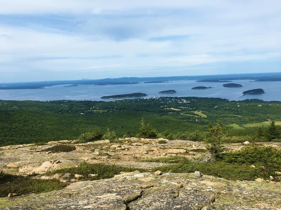
The path climbs through scrubby hardwoods to a short steep pitch and a few rocky ledge scrambles. It opens onto a small, bare summit with Eagle Lake below and Pemetic Mountain, the Bubbles, and Cadillac around the horizon. The open ledges can be hot in strong sun, and the rock is slick when wet. From the top, include the lake below the wooded ridge for the clearest sense of the view.

A hillside recovering from fireThe scrubby hardwoods on the north slope were described as recovering from the 1947 fire, which…

The scrubby hardwoods on the north slope were described as recovering from the 1947 fire, which burned thousands of acres on Mount Desert Island. The rocky summit is small; its appeal is the view across the lake to the surrounding high points.

Wildlife

Wildlife in Acadia

All Acadia wildlife maps

Sighting maps show where each species has been reported across Acadia. Wildlife moves, so no sighting is guaranteed.

Keep exploring

Near Conners Nubble Trail

See it all on the map

Trails that start nearby

Places near the trailhead

Parkwolf’s Acadia ranking

Top-rated trails in Acadia

All 142 trails
  1. 1Beehive Loop TrailChallenging · 1.4 mi
  2. 2Precipice TrailChallenging · 2.1 mi
  3. 3Jordan Pond PathModerate · 3.3 mi
  4. 4Bubbles TrailModerate · 1.5 mi
  5. 5Ocean PathEasy · 2.2 mi
  6. 6Cadillac Mountain South Ridge TrailChallenging · 7.8 mi

Take Parkwolf to Acadia.

The audio tour guide for the drive, plus offline maps, trails, and wildlife heatmaps for when the signal drops.

4.7 from 8,600+ ratings

Download Parkwolf on the App StoreGet Parkwolf on Google Play