Wilkin Valley–East Matukituki Traverse in Mount Aspiring National Park

Mount Aspiring National Park, OT · WC

Wilkin Valley–East Matukituki Traverse

Expert alpine crossing over Rabbit Pass into the East Matukituki.

Length
38km
Time
17hr
Elev. change
1,091m
Difficulty
Challenging
  • No dogs
  • High point 1,426 m
Parkwolf audio tour80 stories across Mount Aspiring’s roads

Overview

About Wilkin Valley–East Matukituki Traverse

Why go

  • A rare high alpine traverse between the Wilkin and East Matukituki valleys.
  • Distinctive route over Waterfall Face and 1,430 m Rabbit Pass.

Heads up

  • Exposed, poorly visible terrain with serious consequences in bad conditions.
  • Remote access, overnight staging and challenging river crossings.

Map & elevation

The route

Loading the Mount Aspiring map
Full map
Elevation335–1,426 m
TrailheadTop Forks Hut-44.27448, 168.89094
Keep this map with you offline in the Parkwolf app

Plan your hike

Before you go

Parking

The route starts at Top Forks Hut, not a roadhead. Vehicle access is Wilkin Road off SH6; reaching the hut requires the separate Makarora-to-Kerin Forks and Kerin Forks-to-Top Forks stages. The point-to-point traverse exits at Cameron Flat, so arrange transport from there.

Safety

For experienced alpine trampers only. Waterfall Face is dangerously exposed and slippery even when dry; do not attempt it wet, windy or under snow. The route has a steep rockslide, falling-rock risk and complex avalanche terrain, especially May–November. Access river crossings require experience, and the exit river can be impassable after rain. Domestic animals are prohibited in the national park.

1 active Mount Aspiring alert

  • CautionRob Roy Track: stop at lower lookout during avalanche seasonFrom May through November, end your Rob Roy Track hike at the lower lookout; DOC strongly recommends against continuing to the upper lookout because the track crosses active avalanche paths.Official details
Mount Aspiring alerts
A park ranger sits on a dash-mounted phone, talking, as Parkwolf’s Tour Guide plays “Army Cutworm Moths: A Grizzly Bear Buffet” on Grand Loop Road below Dunraven Pass in Yellowstone
Parkwolf Tour GuideThe highest, rockiest slopes around here are a summer buffet for grizzly bears.

Mount Aspiring Tour Guide

Your drive to Wilkin Valley–East Matukituki Traverse, narrated.

Parkwolf is a GPS audio tour guide for Mount Aspiring National Park. As you drive, it chimes in with what’s ahead: hidden gems, upcoming stops, history, geology, and wildlife, right through your car’s speakers.

See the Mount Aspiring audio tour
  • 80 audio storiesacross Mount Aspiring’s roads, triggered by GPS as you drive
  • Wildlife heatmapsfor Kea, Rockwren, Yellowhead, and 8 more
  • Works offlinemaps, 50 trails, 52 places, and audio download before you lose signal
  • CarPlay readysimple controls built for the drive
★★★★★
“Fantastic app with many points of information… It’s great to just turn on while you’re driving and it gives you an audio tour of the national Park. We love it!!!!”
JMJamesApp Store review
Download Parkwolf on the App StoreGet Parkwolf on Google Play

4.7 from 8,600+ ratings

Trail guide

Hiking Wilkin Valley–East Matukituki Traverse

The crossingThe Wilkin Valley–East Matukituki Traverse is a 38 km (23.

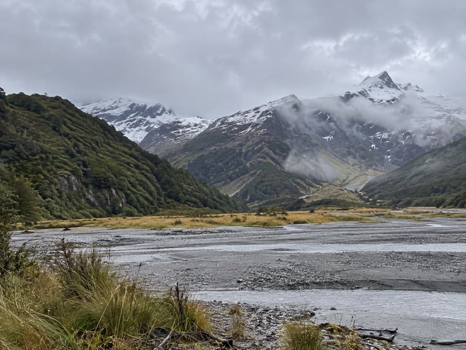
The Wilkin Valley–East Matukituki Traverse is a 38 km (23.6 mi) one-way route from Top Forks Hut over Rabbit Pass to Cameron Flat. The two legs are 20 km to Ruth Flat and 18 km onward to Cameron Flat, with a combined 15–19 hours of walking. This is a remote, multi-day alpine crossing for experienced trampers, not a day walk; the separate approach from Makarora to Top Forks Hut is not included in that distance.

Waterfall FaceFrom Top Forks Hut the route climbs and sidles above a gorge to the South Branch flats; a major…

From Top Forks Hut the route climbs and sidles above a gorge to the South Branch flats; a major slip in the gorge can be difficult to cross. Waterfall Face comes about 3–4 hours from the hut. The route climbs a snow-grass fan to ledges, then crosses a narrow sloping ledge to a ridge above the falls. The grass can be slippery even when dry, and this face is dangerously exposed. Do not attempt it when wet, windy or under snow.

Over Rabbit PassBeyond the face, alpine herb fields lead to Rabbit Pass at 1,430 m.

Beyond the face, alpine herb fields lead to Rabbit Pass at 1,430 m. Follow the shelf east toward Mount Lois, then descend a narrow rockslide through bluffs. Its first 30 m is steep and hazardous, especially when wet; falling rock remains a concern until you are clear. Snow-grass slopes lead down to the valley floor and Ruth Flat, about 1–2 hours beyond the pass. A rock bivvy sits at the bush edge at Ruth Flat.

The East Matukituki exitFrom Ruth Flat, the Bledisloe Gorge track starts about 20 minutes away at the foot of a bush…

From Ruth Flat, the Bledisloe Gorge track starts about 20 minutes away at the foot of a bush spur. It climbs to the bushline, sidles across snow grass and returns to the forest near Hester Pinney Creek before descending to Junction Flat, 4–5 hours from Ruth Flat. Cross two three-wire bridges to the true right of the East Matukituki and continue down to Glacier Burn, about two hours farther. From there the route follows river flats to the West Matukituki crossing and Cameron Flat. After rain, the river can be impassable; a bridge about an hour upstream is the alternative when the water is too high.

Getting to the startTop Forks Hut is the start of the traverse, but it has no road access.

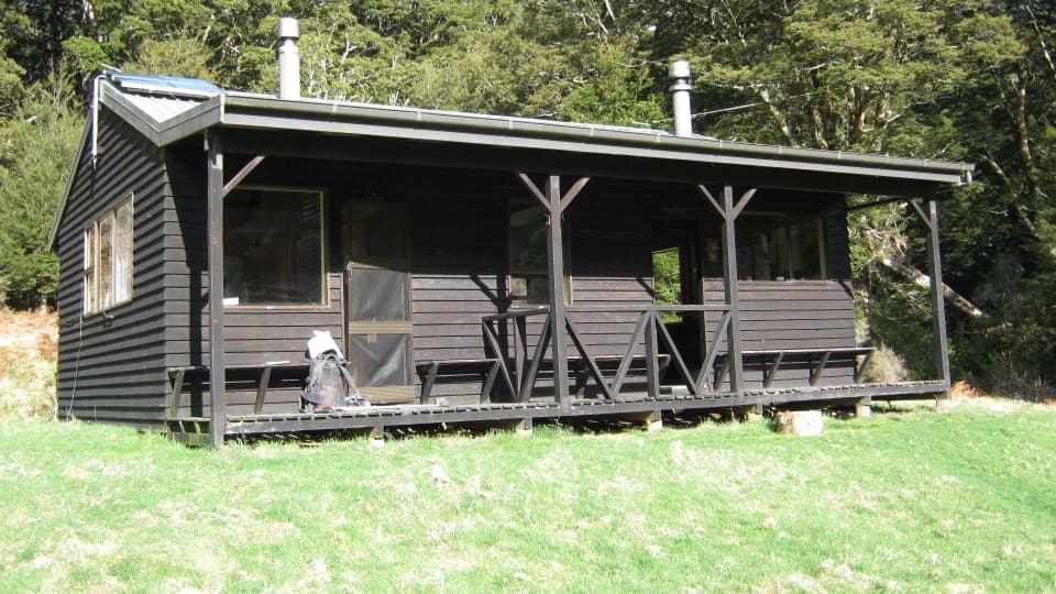
Top Forks Hut is the start of the traverse, but it has no road access. The vehicle access is Wilkin Road off State Highway 6. From there, the separate 15 km walk to Kerin Forks Hut takes about 4–5 hours and involves crossings of the Makarora and Wilkin rivers; Kerin Forks to Top Forks is another 15 km and 6–8 hours. Arrange your Cameron Flat exit transport before setting out. Top Forks Hut has 16 bunks, a non-flush toilet and untreated tap water that must be boiled; bookings are required. Ruth Flat offers a rock bivvy, so carry your own food and overnight supplies.

Conditions and commitmentThe route crosses complex avalanche terrain, especially from May through November, and…

The route crosses complex avalanche terrain, especially from May through November, and significant hazards remain year-round. It is suitable only for experienced alpine trampers; some parties use mountaineering techniques. The access crossings require river-crossing experience, and high water can stop the exit. Domestic animals are not permitted in the national park.

Wildlife

Wildlife in Mount Aspiring

All Mount Aspiring wildlife maps

Sighting maps show where each species has been reported across Mount Aspiring. Wildlife moves, so no sighting is guaranteed.

Parkwolf’s Mount Aspiring ranking

Top-rated trails in Mount Aspiring

All 50 trails
  1. 1Routeburn TrackChallenging · 33.1 km
  2. 2Rob Roy TrackModerate · 10 km
  3. 3Gillespie Pass CircuitChallenging · 56 km
  4. 4Rees-Dart TrackChallenging · 63 km
  5. 5Brewster TrackChallenging · 5.6 km
  6. 6Blue Pools TrackEasy · 3.2 km

Take Parkwolf to Mount Aspiring.

The audio tour guide for the drive, plus offline maps, trails, and wildlife heatmaps for when the signal drops.

4.7 from 8,600+ ratings

Download Parkwolf on the App StoreGet Parkwolf on Google Play