Sunrise Road Pullout in Mount Rainier National Park

Scenic pullout · Mount Rainier National Park

Sunrise Road Pullout

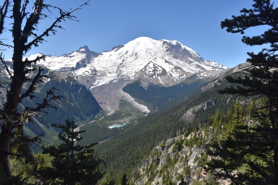
A roadside geology stop for Rainier's volcanic layers and mudflow deposits.

Photo: National Park Service
Type
Scenic pullout
Nearest trail
0.9 mi
Audio stories
10 nearby
  • Parking
  • Pullout
  • Scenic viewpoint

Hear the audio tour

Sunrise Road: Sideways Lava Columns

Overview

About Sunrise Road Pullout

Why stop

  • A road cut makes Rainier's volcanic layers visible without a hike.

Heads up

  • It's a brief, single-view stop, and the loose slope is unsafe to approach.

Map

Where it is

Loading the Mount Rainier map
Full map
Scenic pulloutSunrise Road Pullout46.90483, -121.58410
Keep this map with you offline in the Parkwolf app

Plan your stop

Before you go

7 active Mount Rainier alerts

  • ClosureWildfire closures in the northern parkGrand Park 2 and Wonderland Complex fire closures affect trails, backcountry camps, and Sunrise access; stay out of closed areas.Official details
  • ClosureSR 165 bridge closed: no public access to Carbon River or Mowich LakeThe SR 165 Carbon River/Fairfax Bridge is closed to vehicles, bicycles, and pedestrians; there is no public access or alternate route to Carbon River or Mowich Lake.Official details

See all 7 alerts
A park ranger sits on a dash-mounted phone, talking, as Parkwolf’s Tour Guide plays “Army Cutworm Moths: A Grizzly Bear Buffet” on Grand Loop Road below Dunraven Pass in Yellowstone
Parkwolf Tour GuideThe highest, rockiest slopes around here are a summer buffet for grizzly bears.

Mount Rainier Tour Guide

Your drive to Sunrise Road Pullout, narrated.

Parkwolf is a GPS audio tour guide for Mount Rainier National Park. As you drive, it chimes in with what’s ahead: hidden gems, upcoming stops, history, geology, and wildlife, right through your car’s speakers.

See the Mount Rainier audio tour

Recorded for this area

Sunrise Road: Sideways Lava Columns
0:00 / 0:27
“You're nearing the columnar rock pullout on Sunrise Road. If you're curious about how this ridge formed, pull fully into the turnout for a close look at the dark rock face. Notice that the narrow columns run sideways.”

Plays on the road 0.4 mi from Sunrise Road Pullout in the Parkwolf Mount Rainier Tour Guide.

More stories near here in the app

  • The Bird That Plants Pines
  • A Red Fox in a Black Coat
  • Sunrise Point: The Roadside Panorama
  • A Pika's Winter Haypile
  • 77 audio storiesacross Mount Rainier’s roads, triggered by GPS as you drive
  • Wildlife heatmapsfor Mountain Goat, Black Bear, Wolverine, and 13 more
  • Works offlinemaps, 99 trails, 87 places, and audio download before you lose signal
  • CarPlay readysimple controls built for the drive
★★★★★
“Fantastic app with many points of information… It’s great to just turn on while you’re driving and it gives you an audio tour of the national Park. We love it!!!!”
JMJamesApp Store review
Download Parkwolf on the App StoreGet Parkwolf on Google Play

4.7 from 8,600+ ratings

Guide

More about Sunrise Road Pullout

A quick stop for the road cutSunrise Road Pullout is a small, unpaved roadside stop 1.6 miles up the road from its gate.

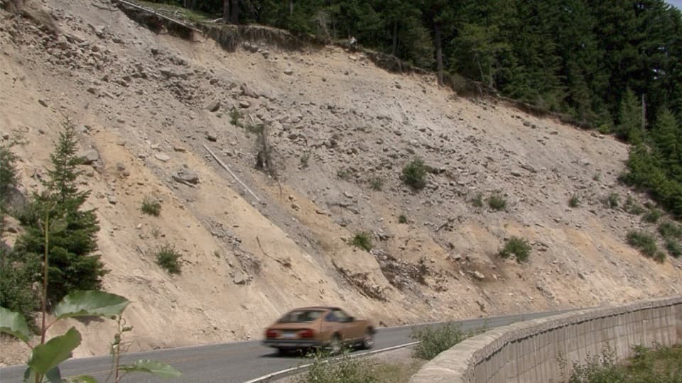
Sunrise Road Pullout is a small, unpaved roadside stop 1.6 miles up the road from its gate. The main view is across the road to a broad exposed hillside. Stop if you'd like a close look at the material that makes up Rainier's slopes; this is a short geology look from the roadside, not a hike or a sweeping mountain overlook.

Read the layersThe exposed cut shows layers of lava, volcanic debris, ash and pumice.

The exposed cut shows layers of lava, volcanic debris, ash and pumice. Some of its boulder-rich material came down in the Osceola Mudflow about 5,600 years ago. Small rockfalls still occur here. Look from the pullout rather than stepping into the ditch at the cut's base, where the footing is unstable. In a photo, include the curve of the road or the stone barrier to give the exposed slope a sense of scale.

Getting to the pulloutThe pullout is on the uphill side of steep, winding Sunrise Road.

The pullout is on the uphill side of steep, winding Sunrise Road. Its shoulder is unpaved, and the route is shared with cyclists and wildlife, so use the pullout rather than stopping in the travel lane. Vehicle access is seasonal, typically from early July to mid-September; check current road conditions before you go.

Wildlife

Wildlife in Mount Rainier

All Mount Rainier wildlife maps

Sighting maps show where each species has been reported across Mount Rainier. Wildlife moves, so no sighting is guaranteed.

Keep exploring

Near Sunrise Road Pullout

See it all on the map

Trails nearby

More stops nearby

Parkwolf’s Mount Rainier ranking

Top sights in Mount Rainier

All 87 places
  1. 1Reflection LakesSight
  2. 2Myrtle FallsSight
  3. 3Panorama PointSight
  4. 4Narada FallsSight
  5. 5Tipsoo LakeSight
  6. 6Sunrise Point OverlookSight

Take Parkwolf to Mount Rainier.

The audio tour guide for the drive, plus offline maps, trails, and wildlife heatmaps for when the signal drops.

4.7 from 8,600+ ratings

Download Parkwolf on the App StoreGet Parkwolf on Google Play