Mount Fremont Lookout Trail in Mount Rainier National Park

#3 of 99 trails in Mount Rainier

Mount Rainier National Park, WA

Mount Fremont Lookout Trail

A rocky ridge climb to Rainier’s 1934 fire lookout.

Photo: National Park Service
Length
5.6mi
Time
3.5hr
Elev. change
768ft
Difficulty
Moderate
  • No dogs
  • High point 7,165 ft

Hear the audio tour

Sunrise: Walk to Emmons Vista

Overview

About Mount Fremont Lookout Trail

Why go

  • A 1934 fire lookout with far-reaching mountain views
  • A varied, open ridge walk from Sunrise

Heads up

  • A rocky, exposed final climb with little shade
  • High elevation makes the mileage feel harder

Map & elevation

The route

Loading the Mount Rainier map
Full map
Elevation6,398–7,165 ft
TrailheadSourdough Ridge Trailhead at Sunrise46.91460, -121.64230
Keep this map with you offline in the Parkwolf app

Plan your hike

Before you go

Parking

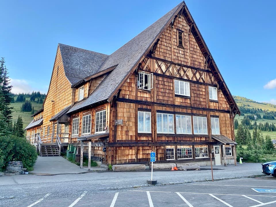
Start at the Sourdough Ridge Trailhead on the north side of the Sunrise parking lot, near the Sunrise Day Lodge and restrooms. The signed approach begins on the service road between them. Parking is busy on popular summer days; an early start helps. No potable water is available at Sunrise.

Safety

The final ridge is rocky, steep in places and exposed, with little shade. The lookout sits at about 7,181 feet. Carry water and sun protection, and turn back if weather makes the ridge unsafe.

7 active Mount Rainier alerts

  • ClosureWildfire closures in the northern parkGrand Park 2 and Wonderland Complex fire closures affect trails, backcountry camps, and Sunrise access; stay out of closed areas.Official details
  • ClosureSR 165 bridge closed: no public access to Carbon River or Mowich LakeThe SR 165 Carbon River/Fairfax Bridge is closed to vehicles, bicycles, and pedestrians; there is no public access or alternate route to Carbon River or Mowich Lake.Official details
See all 7 alerts
A park ranger sits on a dash-mounted phone, talking, as Parkwolf’s Tour Guide plays “Army Cutworm Moths: A Grizzly Bear Buffet” on Grand Loop Road below Dunraven Pass in Yellowstone
Parkwolf Tour GuideThe highest, rockiest slopes around here are a summer buffet for grizzly bears.

Mount Rainier Tour Guide

Your drive to Mount Fremont Lookout Trail, narrated.

Parkwolf is a GPS audio tour guide for Mount Rainier National Park. As you drive, it chimes in with what’s ahead: hidden gems, upcoming stops, history, geology, and wildlife, right through your car’s speakers.

See the Mount Rainier audio tour

Recorded for this trailhead

Sunrise: Walk to Emmons Vista
0:00 / 0:37
“Sunrise is ahead, with the visitor center and day lodge at sixty-four hundred feet. For a short visit, I'd take the half-mile round trip to Emmons Vista and continue past the first overlook to the second.”

Plays as you drive up to this trailhead in the Parkwolf Mount Rainier Tour Guide.

More stories near here in the app

  • Sunrise Road White River View: Rainier's Crater Rim
  • White River: The Campground and Patrol Cabin
  • Beargrass Has No Seven-Year Clock
  • A Pika's Winter Haypile
  • 77 audio storiesacross Mount Rainier’s roads, triggered by GPS as you drive
  • Wildlife heatmapsfor Mountain Goat, Black Bear, Wolverine, and 13 more
  • Works offlinemaps, 99 trails, 87 places, and audio download before you lose signal
  • CarPlay readysimple controls built for the drive
★★★★★
“Fantastic app with many points of information… It’s great to just turn on while you’re driving and it gives you an audio tour of the national Park. We love it!!!!”
JMJamesApp Store review
Download Parkwolf on the App StoreGet Parkwolf on Google Play

4.7 from 8,600+ ratings

Trail guide

Hiking Mount Fremont Lookout Trail

The lookout route from SunriseMount Fremont Lookout Trail is a 5.

Mount Fremont Lookout Trail is a 5.6-mile out-and-back from Sunrise, following Sourdough Ridge to Frozen Lake and then climbing a rocky ridge to the historic fire lookout. Allow about three to four hours, including time to look around. It is a good choice if you want a long stretch of open mountain scenery and a real destination, but the final climb is steeper and rougher than the mileage alone suggests. The route gains about 900 feet by one published figure; other route estimates exceed 1,000 feet, so expect sustained uphill work rather than treating that lower number as a guarantee.

Follow the ridge to Frozen LakeStart at the Sourdough Ridge Trailhead on the north side of the Sunrise parking lot.

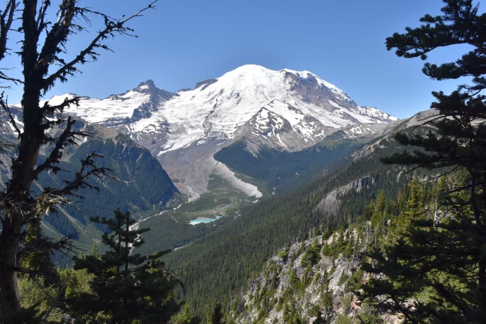
Start at the Sourdough Ridge Trailhead on the north side of the Sunrise parking lot. A service road between the restrooms and Sunrise Day Lodge leads to a broad gravel trail. At the first fork, stay left toward Sourdough Ridge and Frozen Lake. The trail gains the ridge, then runs west through open subalpine meadows and over rocky ground to the junction beside the lake. This first half is scenic without being the main climb: Rainier, the White River valley and the surrounding Cascades keep opening up as the ridge changes angle.

The final climbAt Frozen Lake, take the Mount Fremont branch uphill along the west side of a rocky ridge.

At Frozen Lake, take the Mount Fremont branch uphill along the west side of a rocky ridge. The last 1.3 miles to the lookout gains about 481 feet, with constructed steps in the steeper section. The tread is uneven and can be loose underfoot; there is little shade, and the route stays high and exposed. Take water and sun protection, watch your footing, and leave enough energy for the return. No potable water is available at Sunrise, and there is no water stop to count on along this walk.

At the fire lookoutThe small lookout dates to 1934 and stands at about 7,181 feet, the highest fire lookout in the…

The small lookout dates to 1934 and stands at about 7,181 feet, the highest fire lookout in the park. Firewatchers once used it to spot smoke and lightning and report what they saw by telephone. From the ridge, clear conditions can open views toward Mount Rainier and the Cascades, with Grand Park's broad meadows below to the north; distant peaks are easier to pick out if you bring binoculars. Give yourself time here before turning around. The view is the payoff, not a quick photo stop on the way to another destination.

When the meadows changeThe Sunrise meadows are most colorful in mid to late July, while fall color can begin in…

The Sunrise meadows are most colorful in mid to late July, while fall color can begin in September. Wildlife noted in the area includes mountain goats, marmots, deer and ground squirrels; spotting any of them is never guaranteed, and keep a respectful distance. The open terrain also means little shelter from sun or sudden weather. This is a high mountain route, so check conditions and road access before setting out and be prepared to turn back if the ridge is unsafe.

Make it shorter or plan the startIf you want a shorter outing, walk to Frozen Lake and return the same way, roughly three miles…

If you want a shorter outing, walk to Frozen Lake and return the same way, roughly three miles round trip. You still get the ridge scenery without the steepest climb. For the full hike, use the Sunrise parking lot and begin at the north-side Sourdough Ridge trailhead; popular summer days can make parking difficult later in the morning, so an early start helps. Sunrise access is seasonal, and pets are not allowed on park trails.

Wildlife

Wildlife in Mount Rainier

All Mount Rainier wildlife maps

Sighting maps show where each species has been reported across Mount Rainier. Wildlife moves, so no sighting is guaranteed.

Keep exploring

Near Mount Fremont Lookout Trail

See it all on the map

Trails that start nearby

Places near the trailhead

Parkwolf’s Mount Rainier ranking

Top-rated trails in Mount Rainier

All 99 trails
  1. 1Wonderland TrailChallenging · 93 mi
  2. 2Skyline Trail LoopChallenging · 5.5 mi
  3. 4Burroughs Mountain TrailModerate · 6.2 mi
  4. 5Summerland TrailModerate · 8.4 mi
  5. 6Naches Peak Loop TrailModerate · 3.5 mi
  6. 7Summerland–Panhandle Gap TrailChallenging · 12 mi

Take Parkwolf to Mount Rainier.

The audio tour guide for the drive, plus offline maps, trails, and wildlife heatmaps for when the signal drops.

4.7 from 8,600+ ratings

Download Parkwolf on the App StoreGet Parkwolf on Google Play