Parkhouse Hill in Peak District National Park

Sight · Peak District National Park

Parkhouse Hill

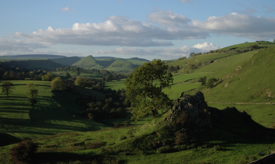
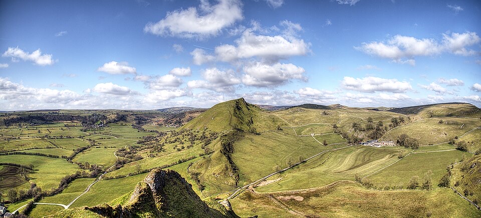
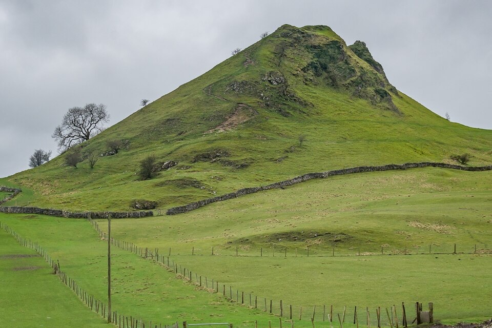
Fossil reef ridge with a steep scramble and Dragon's Back views

Photo: Wikimedia Commons
Type
Sight
Nearest trail
2.2 km
Audio stories
5 nearby

Hear the audio tour

Chrome Hill and Parkhouse Hill: The Dragon's Back

Overview

About Parkhouse Hill

Why stop

  • Distinctive limestone peak with huge White Peak views
  • Memorable short climb with Chrome Hill in the frame

Heads up

  • Steep, rocky ground can be slippery and exposed

Map

Where it is

Loading the Peak District map
Full map
SightParkhouse Hill53.19977, -1.88234
Keep this map with you offline in the Parkwolf app

Plan your stop

Before you go

Best time to go

  • Walkers commonly start from Earl Sterndale, with a well-known moderate circular of about 5.4 miles (8.7 km) linking Parkhouse and Chrome Hills. Other people begin nearer Glutton Bridge or Hollinsclough. Treat these as popular examples rather than a fixed itinerary, and plan your own line from a current map.
  • If you only want the one summit, a direct up-and-down is short, though the descent needs as much care as the climb.
  • Dry weather and full daylight make the biggest difference, because wet rock and steep grass turn an enjoyable scramble into an unforgiving one.
  • For photography, low morning or evening light on clear days picks out the ridge's teeth and the ripple of the surrounding hills; the classic shot is the Dragon's Back profile taken from the neighbouring ground rather than from the top.


Access and terrain

  • The hill is designated access land under the Countryside and Rights of Way Act 2000, so open-access walking on the hill is possible, and public and permissive footpaths run through the surrounding fields.
  • The summit path is rocky and steep, and it rewards good fitness and steady footing.
  • Approaches from the west tend to be looser and steeper, with rock that can be slick when damp; the eastern side is generally gentler. Conditions vary, so judge what you can see rather than committing to a line you cannot reverse.
  • Bring boots or shoes with real grip, layers for exposed wind on the crest, water, and a current map. Sort your kit and supplies before you start walking.

5 active Peak District alerts

  • ClosureA54 Cat and Fiddle road closureThe A54 Macclesfield Main Road (Cat and Fiddle) is fully closed to all traffic from 27 July through 30 October 2026 during phase 1 improvement works.Official details
  • ClosureHooks Carr (Stanage Popular) car park closureHooks Carr (Stanage Popular) car park will be partially or fully closed from 6 October for four weeks.Official details
See all 5 alerts
A park ranger sits on a dash-mounted phone, talking, as Parkwolf’s Tour Guide plays “Army Cutworm Moths: A Grizzly Bear Buffet” on Grand Loop Road below Dunraven Pass in Yellowstone
Parkwolf Tour GuideThe highest, rockiest slopes around here are a summer buffet for grizzly bears.

Peak District Tour Guide

Your drive to Parkhouse Hill, narrated.

Parkwolf is a GPS audio tour guide for Peak District National Park. As you drive, it chimes in with what’s ahead: hidden gems, upcoming stops, history, geology, and wildlife, right through your car’s speakers.

Recorded for this place

Chrome Hill and Parkhouse Hill: The Dragon's Back
0:00 / 0:32
“You're approaching the Dragon's Back, where Chrome Hill and Parkhouse Hill rise in sharp limestone ridges above the Upper Dove Valley.”

Plays as you drive up to Parkhouse Hill in the Parkwolf Peak District Tour Guide.

More stories near here in the app

  • Mud Nests Under the Eaves
  • The Black Tip on the Tail
  • Pilsbury Castle Walk from Longnor
  • An Old Reef on the Skyline
  • 298 audio storiesacross Peak District’s roads, triggered by GPS as you drive
  • Wildlife heatmapsfor Red Deer, Red Fox, Eurasian Otter, and 13 more
  • Works offlinemaps, 88 trails, 76 places, and audio download before you lose signal
  • CarPlay readysimple controls built for the drive
★★★★★
“Fantastic app with many points of information… It’s great to just turn on while you’re driving and it gives you an audio tour of the national Park. We love it!!!!”
JMJamesApp Store review
Download Parkwolf on the App StoreGet Parkwolf on Google Play

4.7 from 8,600+ ratings

Guide

More about Parkhouse Hill

Why make the stopThis is one of the distinctive hills in the Upper Dove Valley, a sharp limestone spine rising…

This is one of the distinctive hills in the Upper Dove Valley, a sharp limestone spine rising just north of the River Dove near the Staffordshire and Derbyshire border. At roughly 375 m, it is not a big hill by numbers, but the profile is unusually severe for the White Peak: a narrow, serrated crest that looks almost drawn on. Together with neighbouring Chrome Hill it forms the view widely known as the Dragon's Back.

What the summit is likeA brisk, steep climb from the base, often done in around 10 to 15 minutes if you go straight up.
  • A brisk, steep climb from the base, often done in around 10 to 15 minutes if you go straight up.
  • The upper ground narrows into a rocky ridge where you feel the drop on both sides; the north flank is especially severe.
  • Wide views over pale limestone fields and dales, with Chrome Hill sitting perfectly in the frame to the northwest.
  • Short scrambling sections on rock rather than a graded path, so hands sometimes come into play.
Geology and stewardshipParkhouse and Chrome are limestone reef knolls, the remains of coral reefs that grew in a warm…

Parkhouse and Chrome are limestone reef knolls, the remains of coral reefs that grew in a warm tropical sea around 340 million years ago. That history is visible in the rock, where brachiopods, crinoid stems and corals show up in the reef limestone. The hills form part of a Site of Special Scientific Interest, valued for limestone flora including rare Jacob's Ladder. Please do not collect fossils or hammer the bedrock, keep to sensible lines, and leave plants and loose rock where they are.

Honest drawbacksThe ground is steep, rocky and exposed, and it becomes genuinely slippery in wet conditions.
  • The ground is steep, rocky and exposed, and it becomes genuinely slippery in wet conditions. This is not a casual family stroll.
  • The narrow crest and short scrambles can be uncomfortable if you dislike heights or are carrying young children.
  • Route choice matters, since steep grass and loose rock on the flanks can make an easy-looking line harder than expected.

Wildlife

Wildlife in Peak District

All Peak District wildlife maps

Sighting maps show where each species has been reported across Peak District. Wildlife moves, so no sighting is guaranteed.

Parkwolf’s Peak District ranking

Top sights in Peak District

All 76 places
  1. 1Chatsworth HouseSight
  2. 2Mam TorSight
  3. 3Dovedale Stepping StonesSight
  4. 4Ladybower ReservoirSight
  5. 5Stanage EdgeSight
  6. 6Kinder ScoutSight

Take Parkwolf to Peak District.

The audio tour guide for the drive, plus offline maps, trails, and wildlife heatmaps for when the signal drops.

4.7 from 8,600+ ratings

Download Parkwolf on the App StoreGet Parkwolf on Google Play