Provoking Falls in Algonquin Provincial Park

Sight · Algonquin Provincial Park

Provoking Falls

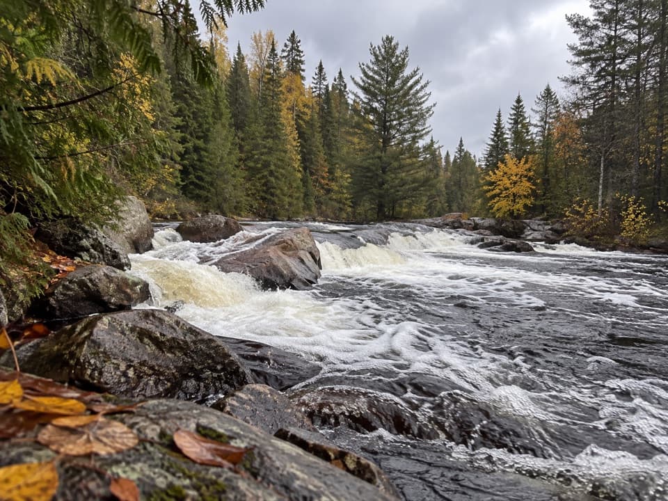
A low, broad cascade for a quiet pause beside the Madawaska.

Type
Sight
Nearest trail
1.2 km
Audio stories
5 nearby
  • Scenic viewpoint

Hear the audio tour

Highland Backpacking Trail

Overview

About Provoking Falls

Why stop

  • Wide rock shelves make the modest cascade interesting up close.

Heads up

  • The falls are small, and the natural river edge is slippery.

Map

Where it is

Loading the Algonquin map
Full map
SightProvoking Falls45.56758, -78.51261
Keep this map with you offline in the Parkwolf app

Plan your stop

Before you go

4 active Algonquin alerts

  • ClosureProvoking Falls Bridge ClosedMentions this placeThe Provoking Falls bridge on the Highland Backpacking Trail is closed because of safety concerns; the bridge has been removed. - Use the posted reroute, which adds 2.5 km.Official details
  • CautionLow Water on Backcountry Canoe RoutesOntario Parks currently lists low-water alerts for six backcountry canoe-route sections: - Varley Lake from Carl Wilson Lake - Latour Creek north of Rosebary Lake - Carcajou Creek north towards…Official details

See all 4 alerts
A park ranger sits on a dash-mounted phone, talking, as Parkwolf’s Tour Guide plays “Army Cutworm Moths: A Grizzly Bear Buffet” on Grand Loop Road below Dunraven Pass in Yellowstone
Parkwolf Tour GuideThe highest, rockiest slopes around here are a summer buffet for grizzly bears.

Algonquin Tour Guide

Your drive to Provoking Falls, narrated.

Parkwolf is a GPS audio tour guide for Algonquin Provincial Park. As you drive, it chimes in with what’s ahead: hidden gems, upcoming stops, history, geology, and wildlife, right through your car’s speakers.

See the Algonquin audio tour

Recorded for this area

Highland Backpacking Trail
0:00 / 0:23
“The Highland Backpacking Trail is ahead, a route for a planned trip camping beside forest lakes.”

Plays on the road 1.2 km from Provoking Falls in the Parkwolf Algonquin Tour Guide.

More stories near here in the app

  • Bat Lake Trail
  • Lake of Two Rivers Store and Cafe
  • Killarney Lodge
  • Hemlock Bluff Trail
  • 107 audio storiesacross Algonquin’s roads, triggered by GPS as you drive
  • Wildlife heatmapsfor Moose, Eastern Wolf, Black Bear, and 13 more
  • Works offlinemaps, 39 trails, 66 places, and audio download before you lose signal
  • CarPlay readysimple controls built for the drive
★★★★★
“Fantastic app with many points of information… It’s great to just turn on while you’re driving and it gives you an audio tour of the national Park. We love it!!!!”
JMJamesApp Store review
Download Parkwolf on the App StoreGet Parkwolf on Google Play

4.7 from 8,600+ ratings

Guide

More about Provoking Falls

A low, broad cascadeProvoking Falls is a small waterfall on the Madawaska River near Mew Lake.

Provoking Falls is a small waterfall on the Madawaska River near Mew Lake. It drops about two metres over a broad shelf of rock, splitting into short cascades rather than one tall plunge. Think quiet riverside detour, not a headline waterfall. It’s a good stop if you’re already nearby and enjoy the sound and texture of moving water.

Check the approachReaching the falls means walking forest paths in the Mew Lake and Highland trail area.

Reaching the falls means walking forest paths in the Mew Lake and Highland trail area. The former bridge across the river at the falls has been removed; the posted reroute adds 2.5 km to the Highland Backpacking Trail, and older directions that send you across the bridge are out of date. Check the current route before setting out. A valid Algonquin permit is required. The natural rocks beside the water are uneven and slippery, with no wheelchair-accessible viewing area.

Watch the water, then the rocksAt lower water, two wider cascades and a smaller side run can show around the rock shelves.

At lower water, two wider cascades and a smaller side run can show around the rock shelves. After spring thaw, higher flow may spread across the shelves and make the separate drops look more continuous. The water level changes the scene, so the rock divisions stand out most when the current is lower.

Follow the old rail corridorThe nearby Old Railway Bike Trail follows the bed of the former Ottawa, Arnprior and Parry…

The nearby Old Railway Bike Trail follows the bed of the former Ottawa, Arnprior and Parry Sound Railway. It runs 16 km between Cache Lake and Rock Lake through forest, lakes and rapids. If your route takes in that corridor, it adds a bit of railway history to a riverside walk.

Photograph the spreadFrom the broad rocks beside the river, frame both main channels with a strip of ledge in the…

From the broad rocks beside the river, frame both main channels with a strip of ledge in the foreground; that shows how far the low falls spread better than a tight crop of the water. Those rocks can be slippery, so keep to secure footing instead of edging closer for a photo.

Wildlife

Wildlife in Algonquin

All Algonquin wildlife maps

Sighting maps show where each species has been reported across Algonquin. Wildlife moves, so no sighting is guaranteed.

Keep exploring

Near Provoking Falls

See it all on the map

Trails nearby

More stops nearby

Parkwolf’s Algonquin ranking

Top sights in Algonquin

All 66 places
  1. 1Barron Canyon LookoutSight
  2. 2Algonquin Logging MuseumSight
  3. 3Lake Opeongo Access Point and Opeongo StoreSight
  4. 4Canoe Lake Access Point and Portage StoreSight
  5. 5Booth's Rock LookoutSight
  6. 6LookoutSight

Take Parkwolf to Algonquin.

The audio tour guide for the drive, plus offline maps, trails, and wildlife heatmaps for when the signal drops.

4.7 from 8,600+ ratings

Download Parkwolf on the App StoreGet Parkwolf on Google Play