Beartooth Basin Summer Ski Area in Beartooth Highway

Sight · Beartooth Highway

Beartooth Basin Summer Ski Area

Summer skiing on a steep high-alpine headwall.

Type
Sight
Nearest trail
0.6 mi
Audio stories
7 nearby
  • Parking

Hear the audio tour

Beartooth Basin Summer Ski Area

Overview

About Beartooth Basin Summer Ski Area

Why stop

  • A rare summer ski hill with steep, wind-shaped terrain.

Heads up

  • Advanced-intermediate or expert ability is expected; there is no warming hut.
Beartooth Basin is a high-alpine summer ski area on the Twin Lakes Headwall beside US-212, near the Montana-Wyoming line. It is a stripped-back setup: two platter lifts serve an operator-described 600 acres, with terrain from 15 to 50 degrees, around 10,900 feet. The operator asks for advanced-intermediate or expert ability, so this is a rare summer ski day for strong skiers and riders, not a casual first-timer stop. If that isn't your level, you can still spot the lift on the highway climb without planning to ski.
Parkwolf’s verdictA specialist summer ski day

Map

Where it is

Loading the Beartooth Highway map
Full map
SightBeartooth Basin Summer Ski Area44.97511, -109.43475
Keep this map with you offline in the Parkwolf app

Plan your stop

Before you go

1 active Beartooth Highway alert

  • ClosureBeartooth Highway seasonal closure and falling-rock advisoryBeartooth Highway (US-212) is closed for the season between Cooke City and Red Lodge; do not plan to travel the highway as a through route.Official details
Beartooth Highway alerts
A park ranger sits on a dash-mounted phone, talking, as Parkwolf’s Tour Guide plays “Army Cutworm Moths: A Grizzly Bear Buffet” on Grand Loop Road below Dunraven Pass in Yellowstone
Parkwolf Tour GuideThe highest, rockiest slopes around here are a summer buffet for grizzly bears.

Beartooth Highway Tour Guide

Your drive to Beartooth Basin Summer Ski Area, narrated.

Parkwolf is a GPS audio tour guide for Beartooth Highway. As you drive, it chimes in with what’s ahead: hidden gems, upcoming stops, history, geology, and wildlife, right through your car’s speakers.

See the Beartooth Highway audio tour

Recorded for this place

Beartooth Basin Summer Ski Area
0:00 / 0:26
“You're coming up on Beartooth Basin, a summer ski area on the steep Twin Lakes Headwall. Two platter lifts serve the snowfield, with terrain for advanced-intermediate and expert skiers and snowboarders.”

Plays as you drive up to Beartooth Basin Summer Ski Area in the Parkwolf Beartooth Highway Tour Guide.

More stories near here in the app

  • Deep Lake Highway Trailhead
  • Gardner Lake Overlook
  • Twin Lakes Overlook
  • A Marmot's Short Summer
  • 62 audio storiesacross Beartooth Highway’s roads, triggered by GPS as you drive
  • Wildlife heatmapsfor Grizzly Bear, Gray Wolf, Bison, and 13 more
  • Works offlinemaps, 82 trails, 36 places, and audio download before you lose signal
  • CarPlay readysimple controls built for the drive
★★★★★
“Fantastic app with many points of information… It’s great to just turn on while you’re driving and it gives you an audio tour of the national Park. We love it!!!!”
JMJamesApp Store review
Download Parkwolf on the App StoreGet Parkwolf on Google Play

4.7 from 8,600+ ratings

Guide

More about Beartooth Basin Summer Ski Area

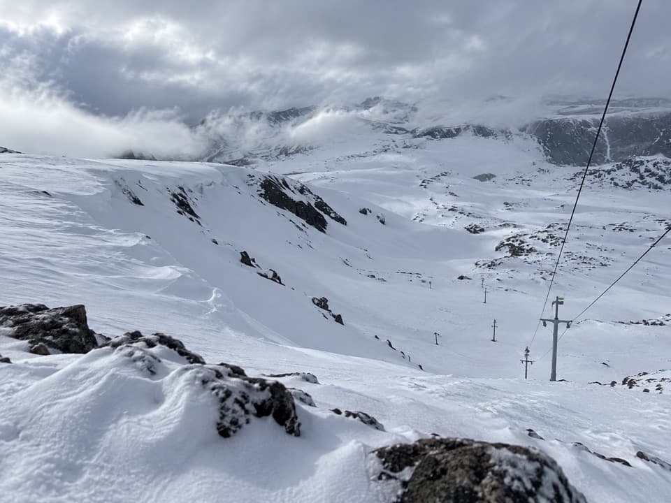
The headwall and the lift lineThe hill is a steep snowfield shaped by wind into rolls, cornices and boulder features.

The hill is a steep snowfield shaped by wind into rolls, cornices and boulder features. The operator also describes jumps and rails in selected zones, but the setup depends on snow and the current operation. Nearby backcountry terrain is separate and reached by shuttle or hike; don't assume it is part of the lift-served hill.

The lift is visible from US-212 as the road climbs, but no safe roadside pullout for a photo was confirmed. The lift cables and towers against the headwall are the defining view; use a proper stopping area rather than treating the shoulder as a viewpoint.

A racing camp above the highwayThe area's roots go back to a summer ski-racing training ground established in the mid-1960s by…

The area's roots go back to a summer ski-racing training ground established in the mid-1960s by Austrian ski figures Pepi Gramshammer, Eric Sailer and Anderl Molterer. It was formerly known as the Red Lodge International Ski and Snowboard Camp and was once used mainly by private teams. The operator also gives 1986 as the Basin's opening date but does not explain how that relates to the earlier training camp, so there isn't one clear public-opening year to repeat.

Plan around snow, storms and servicesThis is a summer-only operation on a high snowfield, so the season depends on snow and mountain…

This is a summer-only operation on a high snowfield, so the season depends on snow and mountain conditions. The operator says it does not run in poor visibility or during electrical storms, and highway access can also affect a ski day. Check both the operator and the highway before making the drive.

There is no lodge or warming hut. Details for public restrooms, water and food service weren't confirmed, so check before expecting resort-base amenities.

Wildlife

Wildlife in Beartooth Highway

All Beartooth Highway wildlife maps

Sighting maps show where each species has been reported across Beartooth Highway. Wildlife moves, so no sighting is guaranteed.

Keep exploring

Near Beartooth Basin Summer Ski Area

See it all on the map

Trails nearby

More stops nearby

Parkwolf’s Beartooth Highway ranking

Top sights in Beartooth Highway

All 36 places
  1. 1Beartooth Pass VistaSight
  2. 2Rock Creek Vista PointSight
  3. 3Clay Butte LookoutSight
  4. 4Pilot and Index Peaks OverlookScenic pullout
  5. 5Beartooth LakeSight
  6. 6Crazy Creek FallsSight

Take Parkwolf to Beartooth Highway.

The audio tour guide for the drive, plus offline maps, trails, and wildlife heatmaps for when the signal drops.

4.7 from 8,600+ ratings

Download Parkwolf on the App StoreGet Parkwolf on Google Play