Bowder Stone Trail in Lake District National Park

Lake District National Park, EN

Bowder Stone Trail

Ten minutes of gravel and woodland to a 30-foot balanced boulder

Photo: Wikimedia Commons
Length
0.9km
Time
30min
Elev. change
27m
Difficulty
Easy
  • Dogs allowed
  • High point 118 m

Hear the audio tour

Bowder Stone: A Woodland Giant

Overview

About Bowder Stone Trail

Why go

  • Massive signature boulder
  • Easy family stop

Heads up

  • Too short to be a standalone hike for many
  • No facilities at the site

Map & elevation

The route

Loading the Lake District map
Full map
Elevation91–118 m
TrailheadBowder Stone National Trust Car Park54.54116, -3.15536
Keep this map with you offline in the Parkwolf app

Plan your hike

Before you go

Parking

Use the National Trust Bowder Stone car park on the B5289, CA12 5XA, about 5 miles outside Keswick and one mile beyond the bridge to Grange. Exit near the ticket machine for the signed track. The car park has about 60 spaces; three disabled bays sit beside the bus stop at the bottom of the access steps.


Safety

The path is short but undulating, with brief steeper sections and uneven gravel. The boulder is reached by viewing steps or ladder, so the final feature is not fully step-free. There are no toilets or refreshments beside the site.

8 active Lake District alerts

  • ClosureChapel Stile footpath closed for retaining-wall riskPart of Footpath 543030 between Chapel Stile and Baysbrown campsite is closed because a retaining wall beside the path could collapse and material it supports could fall across the footpath.Official details
  • ClosureStanley Ghyll Lower Falls footpath closed for rockfallThe section of Footpath 408037 leading towards Stanley Ghyll Lower Falls is closed because severe rockfall damage has made the path unstable and further rockfall remains a danger.Official details
See all 8 alerts
A park ranger sits on a dash-mounted phone, talking, as Parkwolf’s Tour Guide plays “Army Cutworm Moths: A Grizzly Bear Buffet” on Grand Loop Road below Dunraven Pass in Yellowstone
Parkwolf Tour GuideThe highest, rockiest slopes around here are a summer buffet for grizzly bears.

Lake District Tour Guide

Your drive to Bowder Stone Trail, narrated.

Parkwolf is a GPS audio tour guide for Lake District National Park. As you drive, it chimes in with what’s ahead: hidden gems, upcoming stops, history, geology, and wildlife, right through your car’s speakers.

Recorded for this trailhead

Bowder Stone: A Woodland Giant
0:00 / 0:56
“You're nearing the Bowder Stone car park, the starting point for a short woodland walk to a remarkably lopsided boulder.”

Plays as you drive up to this trailhead in the Parkwolf Lake District Tour Guide.

More stories near here in the app

  • Borrowdale: Graphite Under Guard
  • Rosthwaite: Dock Tarn and Great Crag
  • Lodore Falls: The Lower Viewpoint
  • Surprise View: Panorama Without the Climb
  • 298 audio storiesacross Lake District’s roads, triggered by GPS as you drive
  • Wildlife heatmapsfor Red Deer, Eurasian Otter, Osprey, and 13 more
  • Works offlinemaps, 265 trails, 89 places, and audio download before you lose signal
  • CarPlay readysimple controls built for the drive
★★★★★
“Fantastic app with many points of information… It’s great to just turn on while you’re driving and it gives you an audio tour of the national Park. We love it!!!!”
JMJamesApp Store review
Download Parkwolf on the App StoreGet Parkwolf on Google Play

4.7 from 8,600+ ratings

Trail guide

Hiking Bowder Stone Trail

The route in shortThis is a 0.56-mile out-and-back total, roughly 900 m round trip, about 450 m each way.

This is a 0.56-mile out-and-back total, roughly 900 m round trip, about 450 m each way. Allow half an hour if you want time to look properly at the rock and climb the steps. Calling it a hike is generous. Treat it as a stop rather than a day out.

Sequence and payoffLeave the car park by the signed path near the ticket machine, which starts with a short flight…

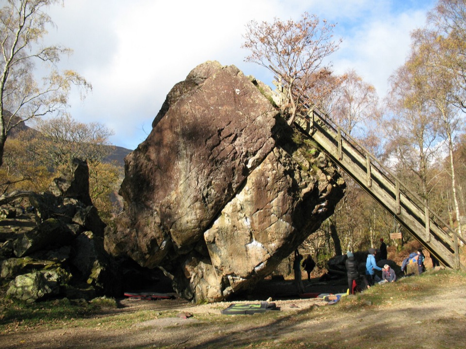
Leave the car park by the signed path near the ticket machine, which starts with a short flight of steps. From there a gravel track runs through woodland with gentle undulations and a couple of brief steeper pulls, then opens out at the Bowder Stone itself. A wooden stair and ladder lets you go up onto the boulder.

The payoff is the object, not a view. The stone stands roughly 30 feet high and sits at an improbable angle. Accounts of how it arrived differ, glacial erratic in some tellings and rockfall from the crags above in others, so enjoy the argument rather than expecting a settled answer.

Footing and difficultyEasy, 2 out of 10, with caveats:

Easy, 2 out of 10, with caveats:

The track itself is often described as wheelchair accessible, and three disabled bays sit at the bottom of the steps beside the bus stop, but do not assume the ladder works for everyone in your group.

  • Gravel surface, uneven in places, likely damp underfoot in this valley
  • Short steeper sections rather than a flat stroll
  • The access steps at the start, and the ladder at the boulder, mean the final feature is not step-free
Scenery and photographyWoodland gives welcome shade and keeps the walk visually enclosed, so this is not the route for…

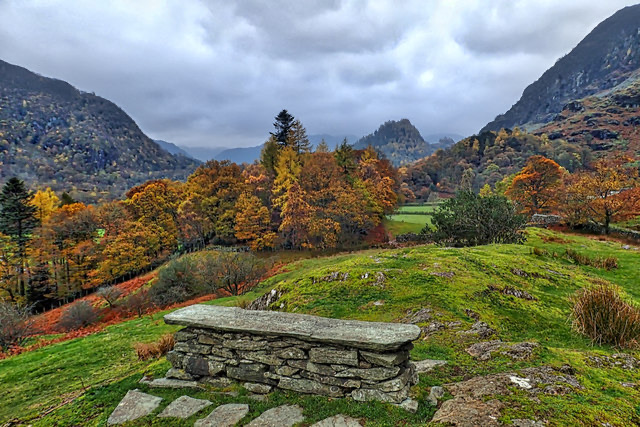
Woodland gives welcome shade and keeps the walk visually enclosed, so this is not the route for Borrowdale panoramas. For photographs, bright overcast or side light brings out the texture and grain of the rock far better than harsh sun, and the tree cover makes contrast tricky at midday.

Access, parking, dogsThe National Trust Bowder Stone car park sits on the B5289 at CA12 5XA, about 5 miles from…

The National Trust Bowder Stone car park sits on the B5289 at CA12 5XA, about 5 miles from Keswick and a mile beyond the bridge to Grange, with around 60 spaces and pay and display. The 78 bus stops at the start, which is the tidier option in a busy valley. No toilets or refreshments at the site, so plan around Keswick or Grange. Dogs are welcome on the route.

If you want moreThe Borger Dalr geology walk starts from the same car park and runs about 6.

The Borger Dalr geology walk starts from the same car park and runs about 6.4 miles as a circular. That is the one to choose if you came to Borrowdale for the rocks and want a proper half day. Pairing the two is sensible; the Bowder Stone alone will not fill a morning.

Wildlife

Wildlife in Lake District

All Lake District wildlife maps

Sighting maps show where each species has been reported across Lake District. Wildlife moves, so no sighting is guaranteed.

Keep exploring

Near Bowder Stone Trail

See it all on the map

Trails that start nearby

Places near the trailhead

Parkwolf’s Lake District ranking

Top-rated trails in Lake District

All 265 trails
  1. 1Scafell Pike via Hollow Stones from WasdaleChallenging · 9 km
  2. 2Helvellyn via Striding Edge and Swirral EdgeChallenging · 12.4 km
  3. 3CatbellsModerate · 6.6 km
  4. 4The Old Man of ConistonChallenging · 9 km
  5. 5Buttermere CircularEasy · 7.6 km
  6. 6The Fairfield HorseshoeChallenging · 17.2 km

Take Parkwolf to Lake District.

The audio tour guide for the drive, plus offline maps, trails, and wildlife heatmaps for when the signal drops.

4.7 from 8,600+ ratings

Download Parkwolf on the App StoreGet Parkwolf on Google Play