Red Rock Canyon Loop Trail in Waterton Lakes National Park

#8 of 47 trails in Waterton Lakes

Waterton Lakes National Park, AB

Red Rock Canyon Loop Trail

A quick paved loop through red, green and pale canyon walls.

Photo: Wikimedia Commons
Length
0.7km
Time
24min
Elev. change
57m
Difficulty
Easy
  • Loop
  • Dogs allowed
  • High point 1,550 m

Hear the audio tour

Red Rock Canyon

Overview

About Red Rock Canyon Loop Trail

Why go

  • Red and green rock layers sit right beside the paved path
  • Short loop with interpretive panels and creek views

Heads up

  • The circuit is over quickly
  • A short uphill stretch and summer parking pressure soften the easy-stroll feel

Map & elevation

The route

Loading the Waterton Lakes map
Full map
Elevation1,493–1,550 m
TrailheadRed Rock Canyon upper parking lot49.13079, -114.02680
Keep this map with you offline in the Parkwolf app

Plan your hike

Before you go

Parking

Start at the Red Rock Canyon upper parking lot; the interpretive panels mark the loop. Summer visits can be busy, so arrive early for a quieter walk and a better chance at a space. Park admission is required. Red Rock Parkway closes to motor vehicles seasonally from October to May, depending on weather.

Safety

Stay on the paved route; the canyon environment is fragile.

7 active Waterton Lakes alerts

  • ClosureBelly River Campground closedBelly River Campground is closed to all traffic and travel because a carcass is in the area. - Violators may be charged under the Canada National Parks Act, with a maximum penalty of $25,000.Official details
  • ClosureBlakiston Fan closed to protect rutting elkThe Blakiston Fan area is closed to traffic and travel to prevent disturbance of elk rutting there.Official details
See all 7 alerts
A park ranger sits on a dash-mounted phone, talking, as Parkwolf’s Tour Guide plays “Army Cutworm Moths: A Grizzly Bear Buffet” on Grand Loop Road below Dunraven Pass in Yellowstone
Parkwolf Tour GuideThe highest, rockiest slopes around here are a summer buffet for grizzly bears.

Waterton Lakes Tour Guide

Your drive to Red Rock Canyon Loop Trail, narrated.

Parkwolf is a GPS audio tour guide for Waterton Lakes National Park. As you drive, it chimes in with what’s ahead: hidden gems, upcoming stops, history, geology, and wildlife, right through your car’s speakers.

See the Waterton Lakes audio tour

Recorded for this trailhead

Red Rock Canyon
0:00 / 0:32
“You’re coming up on Red Rock Canyon, where a creek cuts through red and green rock. This is a good stop for a close look at the landscape without a long hike.”

Plays as you drive up to this trailhead in the Parkwolf Waterton Lakes Tour Guide.

More stories near here in the app

  • Lost Horse Creek Day Use Area
  • Older Rock on Top
  • Coppermine Day Use Area
  • A Squirrel's Cone Store
  • 51 audio storiesacross Waterton Lakes’s roads, triggered by GPS as you drive
  • Wildlife heatmapsfor Bison, Black Bear, Elk, and 13 more
  • Works offlinemaps, 47 trails, 70 places, and audio download before you lose signal
  • CarPlay readysimple controls built for the drive
★★★★★
“Fantastic app with many points of information… It’s great to just turn on while you’re driving and it gives you an audio tour of the national Park. We love it!!!!”
JMJamesApp Store review
Download Parkwolf on the App StoreGet Parkwolf on Google Play

4.7 from 8,600+ ratings

Trail guide

Hiking Red Rock Canyon Loop Trail

A quick canyon loopRed Rock Canyon Loop Trail is a 0.

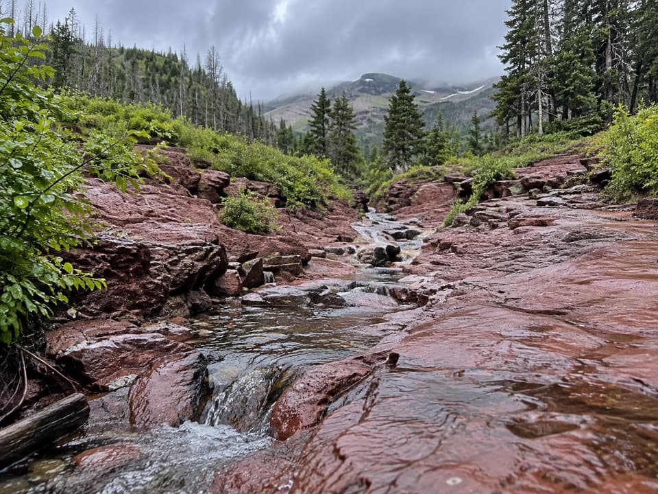
Red Rock Canyon Loop Trail is a 0.44-mile paved loop around and across a small canyon, with red, green and pale rock walls close to the path. It is an easy 20-to-30-minute stop with one short uphill stretch and little overall climbing. Do this for the close-up geology and creek views, not for a long hike.

Walk both sidesStart at the interpretive panels by the upper parking lot.

Start at the interpretive panels by the upper parking lot. The circuit follows both canyon rims and crosses Red Rock Creek at each end, so you get a different angle into the gorge as you go. There is a brief rise near the far end; the rest is a short, easy circuit. Keep to the paved path because the canyon environment is fragile.

What makes the colorsThe red and green bands are argillite, a shale-like rock.

The red and green bands are argillite, a shale-like rock. Iron in the rock turned red where it oxidized and stayed green where it did not; pale stretches are limestone or dolomite. These layers began as sediment at the bottom of an ancient sea about 1.5 billion years ago. The interpretive panels help make those colors more than just a pretty view.

Put water in the pictureFrom the rim path, frame a little creek below the red and pale bands instead of aiming only at…

From the rim path, frame a little creek below the red and pale bands instead of aiming only at the rock wall. The water breaks up the bands and shows how close the trail runs to the canyon.

Make the parkway trip countUse the upper canyon lot for this loop; the lower lot is the start for the separate Blakiston…

Use the upper canyon lot for this loop; the lower lot is the start for the separate Blakiston Falls walk. In summer the paths and upper parking area can get busy, so arrive early for a quieter visit and a better chance at a space. Park admission is required. Dogs are welcome on the trail when leashed and under control. Red Rock Parkway closes to vehicles seasonally from October to May, depending on weather, so check road access before driving up. If you want more walking, Blakiston Falls is a separate 1.2-mile return from the lower lot.

Wildlife

Wildlife in Waterton Lakes

All Waterton Lakes wildlife maps

Sighting maps show where each species has been reported across Waterton Lakes. Wildlife moves, so no sighting is guaranteed.

Keep exploring

Near Red Rock Canyon Loop Trail

See it all on the map

Trails that start nearby

Places near the trailhead

Parkwolf’s Waterton Lakes ranking

Top-rated trails in Waterton Lakes

All 47 trails
  1. 1Crypt Lake TrailChallenging · 17.1 km
  2. 2Carthew-Alderson TrailChallenging · 20.1 km
  3. 3Bear’s Hump TrailModerate · 2.9 km
  4. 4Bertha Lake TrailModerate · 10.3 km
  5. 5Lineham RidgeChallenging · 17.2 km
  6. 6Upper Rowe Lake TrailModerate · 12.8 km

Take Parkwolf to Waterton Lakes.

The audio tour guide for the drive, plus offline maps, trails, and wildlife heatmaps for when the signal drops.

4.7 from 8,600+ ratings

Download Parkwolf on the App StoreGet Parkwolf on Google Play