Parking
Use the Apgar Lookout Trailhead, 0.5 mile north of the West Entrance and 2.4 miles down Quarter Circle Bridge Road.

Glacier National Park, MT
Steep switchbacks through the 2003 burn climb to a fire lookout.
Overview
Map & elevation
Plan your hike

The highest, rockiest slopes around here are a summer buffet for grizzly bears.
Glacier Tour Guide
Parkwolf is a GPS audio tour guide for Glacier National Park. As you drive, it chimes in with what’s ahead: hidden gems, upcoming stops, history, geology, and wildlife, right through your car’s speakers.
See the Glacier audio tourRecorded for this trailhead
Apgar Lookout Trailhead“You're approaching Apgar Lookout Trailhead, the start of a steep hike to a wooden fire lookout above Lake McDonald.”
Plays as you drive up to this trailhead in the Parkwolf Glacier Tour Guide.
More stories near here in the app
“Our first time to glacier and we used the audio portion for Going to the Sun Road. Wonderful information with perfect advice of what to see and do along the road.”


Trail guide
Apgar Lookout Trail is a 7.2-mile out-and-back from the Apgar Lookout Trailhead to Apgar Fire Lookout, about 3.6 miles each way. The climb gains roughly 1,900 feet, with a short dip before the lookout, so allow about four to five hours. It is a hard, steady uphill walk rather than a quick viewpoint stop. The payoff is a real wooden fire lookout above Lake McDonald.
The lower stretch begins along an old dirt road and is easier walking. About three-quarters of a mile in, the sustained climb starts; long switchbacks carry you up the southwest slope for most of the next 2.7 miles. Keep some energy for the way back: this is an out-and-back, so you retrace the same climb and trail.
The route crosses open slopes affected by the 2003 Robert Fire. Fire crews used a managed burnout on Apgar Mountain to slow the fire and protect nearby communities. The sunny south-facing climb can feel hot in summer, and the open burned sections offer less shelter than a forest walk. Carry water from the start.
The trail ends at Apgar Fire Lookout on a ridge below Apgar Mountain's high point. Lake McDonald, Howe Ridge and the surrounding valley are the main views; trees and the communications equipment near the lookout break up parts of the panorama. For a photograph that places you on this hike, include the wooden lookout in the frame instead of shooting only across the lake.
The trailhead is 0.5 mile north of the West Entrance and 2.4 miles down Quarter Circle Bridge Road. Use the Apgar Lookout Trailhead as the start for the mileage above. Dogs are not permitted on Glacier's trails. Bring the water and food you need for the full climb; no refill or food stop on the route was confirmed.
Wildlife
 404 sightingsGrizzly BearMost seen around 6 AMSighting map
 11 sightingsWolverineMost seen around 8 PMSighting map
 1,173 sightingsMountain GoatMost seen around 6 AMSighting map
 1,000 sightingsBighorn SheepMost seen around 6 AMSighting map
 395 sightingsMooseMost seen around 6 AMSighting map
 506 sightingsBlack BearMost seen around 8 PMSighting map
Sighting maps show where each species has been reported across Glacier. Wildlife moves, so no sighting is guaranteed.
Keep exploring
 EasyOld Flathead Ranger Station Trail6.9 mi · 3 hr · 0.4 mi awayA gentle old road leads to the Flathead River confluence.
 EasyApgar Bike Path3 mi · 1.2 hr · 1.8 mi awayFlat, shaded pavement links Apgar Village with Park Headquarters.
 EasyBelton Bridge Trail1 mi · 30 min · 1.9 mi awayA level riverside walk to the old entrance bridge.
 ChallengingSouth Boundary Trail11.5 mi · 5.3 hr · 2.4 mi awayFollow the Middle Fork through an old ranger route to Lincoln Creek.
 EasyFish Creek Bike Path1.2 mi · 30 min · 2.7 mi awayA short, mostly level path through the woods to Fish Creek.
 ChallengingSnyder Ridge Trail12.6 mi · 9 hr · 3.4 mi awayHard miles in the trees, with Fish Lake waiting near the end.
 EasyRocky Point Nature Trail1.8 mi · 1.3 hr · 3.6 mi awayA lakeside loop to Rocky Point and its mountain views.
 ChallengingHowe Ridge Trail11.6 mi · 9 hr · 4.6 mi awayA rough ridge traverse where route-finding matters as much as climbing.
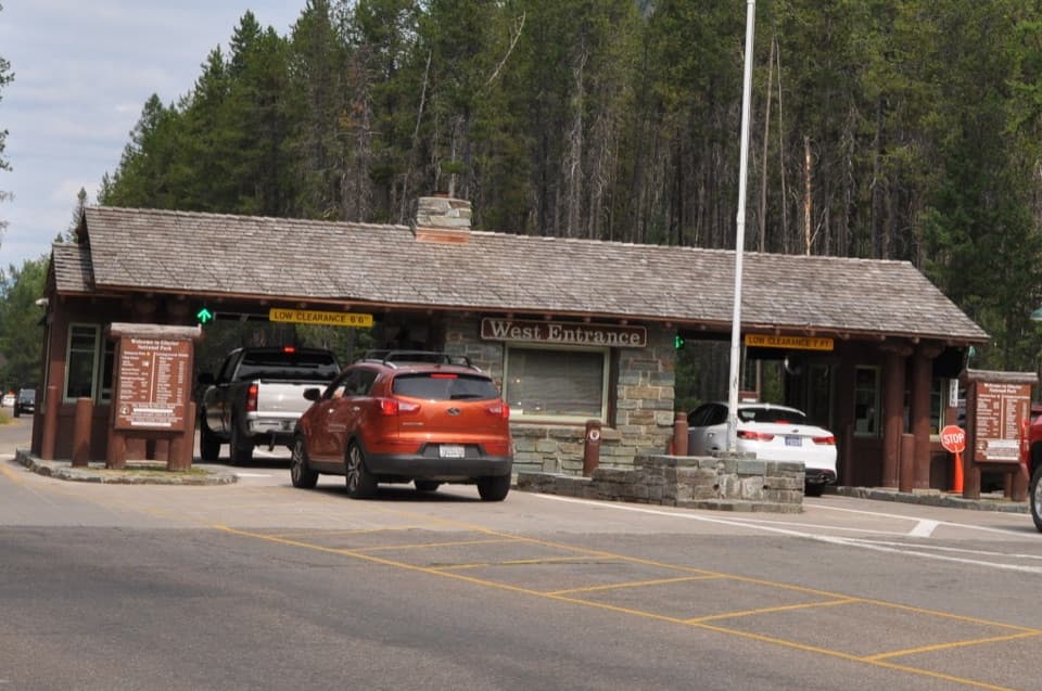 Entrance station · 1.5 mi awayWest Entrance StationA CCC-built 1941 checkpoint with a distinctive rustic tollbooth design.
 Sight · 2 mi awayApgar Wilderness Permit CenterA practical planning stop before a backcountry overnight trip.
 Visitor center · 2 mi awayApgar Visitor CenterSort out your west-side plan, then hop on the park shuttle.
 Sight · 2 mi awayHistoric Belton DepotA 1910 rail depot turned bookstore, with park passport stamps.
 Lodging · 2 mi awayApgar Village Lodge & CabinsSleep beside Lake McDonald in cabins or simple motel rooms.
 Sight · 2.1 mi awayApgar Nature CenterTouch animal pelts and build mountains in a 1929 Apgar cabin.
 Sight · 2.1 mi awayApgar VillageFood, boats and lake access share the west shore.
 Lodging · 2.1 mi awayBelton ChaletA 1910 railway chalet still serving dinner beneath its timber gables.
Parkwolf’s Glacier ranking

The audio tour guide for the drive, plus offline maps, trails, and wildlife heatmaps for when the signal drops.