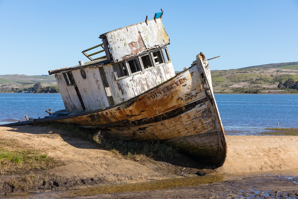
Point Reyes Shipwreck in Point Reyes National Seashore

Sight · Point Reyes National Seashore

Point Reyes Shipwreck

Collapsing wooden fishing boat settled into Tomales Bay mudflats

Photo: Wikimedia Commons
Type
Sight
Nearest trail
1.5 mi
Audio stories
6 nearby
  • #13 of 30 sights

Hear the audio tour

Point Reyes Shipwreck

Overview

About Point Reyes Shipwreck

Why stop

  • Unusual waterfront photo subject
  • Easy quick stop

Heads up

  • Much of the boat has collapsed
  • Muddy or tide-affected viewing
A weathered wooden fishing boat sits beached on the Tomales Bay shoreline in downtown Inverness, close enough to the road that it takes only a few minutes to see. It is an unusual waterfront photo subject and a quick, distinctive break on a longer Point Reyes day. It is not worth a dedicated trip on its own.
Parkwolf’s verdictWhy stop

Map

Where it is

Loading the Point Reyes map
Full map
SightPoint Reyes Shipwreck38.09783, -122.85073
Keep this map with you offline in the Parkwolf app

Plan your stop

Before you go

Access and etiquette

  • The boat sits on National Park Service land, but the surrounding shoreline access crosses private property.
  • The public view is from the east end of the Inverness Store parking lot, a short walk from the market lot.
  • Do not trespass anywhere else to get closer or find a different angle.
  • Do not climb on or touch the wreck. The remaining structure is unsound and protected.

4 active Point Reyes alerts

  • ClosureOld Tocaloma/Platform Bridge closed to vehiclesDo not drive across the Old Tocaloma/Platform Bridge; it is closed to all vehicular traffic until further notice.Official details
  • ClosurePalomarin Beach Trail closedPalomarin Beach Trail is closed to all visitors, employees, and residents until further notice; do not use the trail. - The trail is closed because unstable and failing sections have made it unsafe.Official details
See all 4 alerts
A park ranger sits on a dash-mounted phone, talking, as Parkwolf’s Tour Guide plays “Army Cutworm Moths: A Grizzly Bear Buffet” on Grand Loop Road below Dunraven Pass in Yellowstone
Parkwolf Tour GuideThe highest, rockiest slopes around here are a summer buffet for grizzly bears.

Point Reyes Tour Guide

Your drive to Point Reyes Shipwreck, narrated.

Parkwolf is a GPS audio tour guide for Point Reyes National Seashore. As you drive, it chimes in with what’s ahead: hidden gems, upcoming stops, history, geology, and wildlife, right through your car’s speakers.

Recorded for this place

Point Reyes Shipwreck
0:00 / 0:28
“You're coming up on the Point Reyes Shipwreck behind Inverness Store.”

Plays as you drive up to Point Reyes Shipwreck in the Parkwolf Point Reyes Tour Guide.

More stories near here in the app

  • Why Inverness Sounds Scottish
  • The Ray Wasn't the Oyster Thief
  • The Beaver Without a Pond
  • Mount Vision Overlook
  • 61 audio storiesacross Point Reyes’s roads, triggered by GPS as you drive
  • Wildlife heatmapsfor Northern Elephant Seal, Grey Whale, Humpback Whale, and 13 more
  • Works offlinemaps, 65 trails, 41 places, and audio download before you lose signal
  • CarPlay readysimple controls built for the drive
★★★★★
“Fantastic app with many points of information… It’s great to just turn on while you’re driving and it gives you an audio tour of the national Park. We love it!!!!”
JMJamesApp Store review
Download Parkwolf on the App StoreGet Parkwolf on Google Play

4.7 from 8,600+ ratings

Guide

More about Point Reyes Shipwreck

What is actually leftThe boat was bought by an Inverness resident who meant to repair it and instead beached it here.

The boat was bought by an Inverness resident who meant to repair it and instead beached it here. A fire in February 2016 badly damaged the hull, and by 2023 the sides had largely collapsed. Expect a fragile, half-fallen shell rather than a photogenic intact boat. Older photos circulating online were taken before the fire and make it look far more complete than it is now.

Tide, mud, and footwearWater level changes the scene more than anything else here.

Water level changes the scene more than anything else here. Lower tide exposes more of the sandbar and gives a closer, cleaner view, while higher water can leave the approach damp or partly submerged. The ground is often muddy depending on season and tide, so bring shoes you do not mind getting wet or dirty, and add a wind layer since the bay side is exposed and cool.

Honest drawbacksMuch of the boat has collapsed, so the payoff is smaller than photos suggest.
  • Much of the boat has collapsed, so the payoff is smaller than photos suggest.
  • Viewing is limited to permitted public areas, with no established trail or formal viewing area.
  • Muddy or tide-covered ground can cut the visit short.
  • Plan on 10 to 20 minutes, treated as one stop among others in the area.

Wildlife

Wildlife in Point Reyes

All Point Reyes wildlife maps

Sighting maps show where each species has been reported across Point Reyes. Wildlife moves, so no sighting is guaranteed.

Keep exploring

Near Point Reyes Shipwreck

See it all on the map

Trails nearby

More stops nearby

Parkwolf’s Point Reyes ranking

Top sights in Point Reyes

All 41 places
  1. 1Point Reyes LighthouseSight
  2. 2Chimney RockSight
  3. 3Drakes BeachBeach
  4. 4Cypress Tree TunnelSight
  5. 5Alamere FallsSight
  6. 6Pierce Point RanchSight

Take Parkwolf to Point Reyes.

The audio tour guide for the drive, plus offline maps, trails, and wildlife heatmaps for when the signal drops.

4.7 from 8,600+ ratings

Download Parkwolf on the App StoreGet Parkwolf on Google Play