Cypress Tree Tunnel in Point Reyes National Seashore

#4 of 30 sights in Point Reyes

Sight · Point Reyes National Seashore

Cypress Tree Tunnel

Quarter mile of 1930s Monterey cypress arched into a green tunnel

Photo: National Park Service
Type
Sight
Nearest trail
1.2 mi
Audio stories
4 nearby
  • Parking
  • Exhibit

Hear the audio tour

Cypress Tree Tunnel and KPH Station

Overview

About Cypress Tree Tunnel

Why stop

  • Iconic cypress canopy framing a historic radio station
  • Easy, distinctive photography stop

Heads up

  • Well-known photo stop can feel busy
  • Limited roadside parking
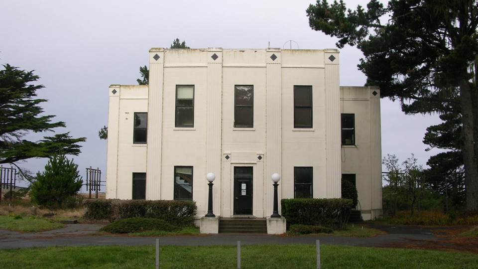
A double row of Monterey cypress, planted around 1930, runs about a quarter mile from Sir Francis Drake Boulevard to a white Art Deco radio building. By the 1980s the upper limbs had grown together overhead, and the result is a walkable green corridor that frames the building at the far end. It is a well-known photo stop, and seeing it takes little effort.
Parkwolf’s verdictWhy stop

Map

Where it is

Loading the Point Reyes map
Full map
SightCypress Tree Tunnel38.09380, -122.94540
Keep this map with you offline in the Parkwolf app

Plan your stop

Before you go

Parking and root etiquette

  • Parking is on the shoulder of Sir Francis Drake Boulevard. Pull fully off the road.
  • Do not park along the driveway or on top of the trees' roots. Compacted soil over the root zone damages them.
  • The allee road is closed to vehicle traffic to limit root damage, so plan to walk it rather than drive it.
  • Stay out of the operations areas that are not open to visitors.

4 active Point Reyes alerts

  • ClosureOld Tocaloma/Platform Bridge closed to vehiclesDo not drive across the Old Tocaloma/Platform Bridge; it is closed to all vehicular traffic until further notice.Official details
  • ClosurePalomarin Beach Trail closedPalomarin Beach Trail is closed to all visitors, employees, and residents until further notice; do not use the trail. - The trail is closed because unstable and failing sections have made it unsafe.Official details
See all 4 alerts
A park ranger sits on a dash-mounted phone, talking, as Parkwolf’s Tour Guide plays “Army Cutworm Moths: A Grizzly Bear Buffet” on Grand Loop Road below Dunraven Pass in Yellowstone
Parkwolf Tour GuideThe highest, rockiest slopes around here are a summer buffet for grizzly bears.

Point Reyes Tour Guide

Your drive to Cypress Tree Tunnel, narrated.

Parkwolf is a GPS audio tour guide for Point Reyes National Seashore. As you drive, it chimes in with what’s ahead: hidden gems, upcoming stops, history, geology, and wildlife, right through your car’s speakers.

Recorded for this place

Cypress Tree Tunnel and KPH Station
0:00 / 0:34
“Up ahead is the Cypress Tree Tunnel, a quarter-mile walk between Monterey cypress planted around 1930. Their branches meet over the old driveway and frame the white Art Deco KPH radio station at the far end.”

Plays as you drive up to Cypress Tree Tunnel in the Parkwolf Point Reyes Tour Guide.

More stories near here in the app

  • Drakes Estero Kayak Launch
  • Point Reyes Beach North
  • Estero Trailhead and Home Bay
  • Abbotts Lagoon
  • 61 audio storiesacross Point Reyes’s roads, triggered by GPS as you drive
  • Wildlife heatmapsfor Northern Elephant Seal, Grey Whale, Humpback Whale, and 13 more
  • Works offlinemaps, 65 trails, 41 places, and audio download before you lose signal
  • CarPlay readysimple controls built for the drive
★★★★★
“Fantastic app with many points of information… It’s great to just turn on while you’re driving and it gives you an audio tour of the national Park. We love it!!!!”
JMJamesApp Store review
Download Parkwolf on the App StoreGet Parkwolf on Google Play

4.7 from 8,600+ ratings

Guide

More about Cypress Tree Tunnel

What makes it distinctiveThe species fits the place.
  • The species fits the place. Monterey cypress is unusually well suited to this headland's wind and ocean weather, which is why the planting has thrived here for roughly a century.
  • It is a designed allee, not a wild grove. The trees were planted as landscaping for a working communications station.
  • The view has a subject. Instead of ending in open ground, the corridor closes on the historic receiving station facade.
The history at the end of the treesThe white Art Deco-style receiving station was built between 1929 and 1931 and handled…

The white Art Deco-style receiving station was built between 1929 and 1931 and handled ship-to-shore communications for most of the twentieth century. Restored radio equipment and the site's Morse-code legacy are part of what makes the location matter, though the trees are the main visitor-facing draw. The allee is a contributing resource of the RCA Point Reyes Receiving Station Historic District, listed on the National Register of Historic Places in 2018.

How to find itAddress: 17400 Sir Francis Drake Boulevard, along the road heading out toward the lighthouse.
  • Address: 17400 Sir Francis Drake Boulevard, along the road heading out toward the lighthouse.
  • Watch for signs to the North District Operations Center. That is the site the tunnel belongs to.
  • The entrance is easy to blow past at speed, so slow down as you approach.
What to expectAn easy, peaceful walk down and back on the old road, with the historic buildings waiting at…

An easy, peaceful walk down and back on the old road, with the historic buildings waiting at the end. It is a short stop that pairs naturally with the drive out toward the lighthouse or the Estero area. Bring your camera, and bring a wind layer, because this is exposed coastal country.

Honest drawbacksFacilities are elsewhere.
  • Facilities are elsewhere. The nearest restrooms are at Estero Trailhead and North Beach, so plan accordingly before you arrive.
  • Roadside shoulder parking is the only option, and it is limited.
  • The photo everyone wants is a well-known one, so other people may be doing exactly the same thing when you arrive.
  • Access inside the historic radio buildings is not something to count on. Treat the tree tunnel itself as the reason you came.

Wildlife

Wildlife in Point Reyes

All Point Reyes wildlife maps

Sighting maps show where each species has been reported across Point Reyes. Wildlife moves, so no sighting is guaranteed.

Keep exploring

Near Cypress Tree Tunnel

See it all on the map

Trails nearby

More stops nearby

Parkwolf’s Point Reyes ranking

Top sights in Point Reyes

All 41 places
  1. 1Point Reyes LighthouseSight
  2. 2Chimney RockSight
  3. 3Drakes BeachBeach
  4. 5Alamere FallsSight
  5. 6Pierce Point RanchSight
  6. 7Tomales PointSight

Take Parkwolf to Point Reyes.

The audio tour guide for the drive, plus offline maps, trails, and wildlife heatmaps for when the signal drops.

4.7 from 8,600+ ratings

Download Parkwolf on the App StoreGet Parkwolf on Google Play