Taylor Creek Trail in Zion National Park

Zion National Park, UT

Taylor Creek Trail

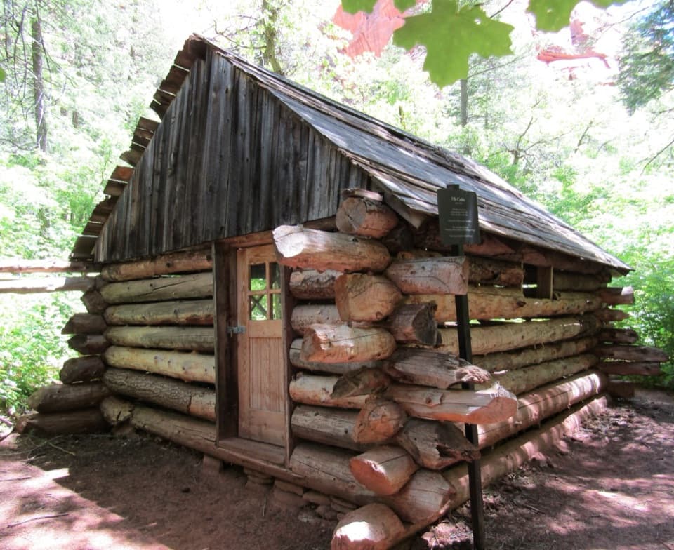
Two homestead cabins lead to a shaded sandstone alcove.

Photo: CC BY 2.0
Length
5.2mi
Time
3.5hr
Elev. change
505ft
Difficulty
Moderate
  • No dogs
  • High point 5,951 ft
  • #11 of 54 in Zion

Hear the audio tour

Taylor Creek and Double Arch Alcove

Overview

About Taylor Creek Trail

Why go

  • A shaded creek walk ends at a distinctive, streaked alcove
  • Two early-1930s cabins add human history to the canyon

Heads up

  • Frequent creek crossings make dry feet uncertain
  • The short descent from the lot becomes a climb on the return

Map & elevation

The route

Loading the Zion map
Full map
Elevation5,446–5,951 ft
TrailheadTaylor Creek Trailhead37.46188, -113.19945
Keep this map with you offline in the Parkwolf app

Plan your hike

Before you go

Parking

Park at Taylor Creek Trailhead on Kolob Canyons Road. Pit toilets are available there. Visitor reports say the lot can fill on busy days, though availability varies. Refill water at Kolob Canyons Visitor Center; there is no water along the route.

Safety

Frequent creek crossings can wet your feet, and seasonal flow changes their depth. Expect soft sand, boulders, and stair-like rocks; the initial descent must be climbed on the way back. Wilderness groups are limited to 12 people who share an affiliation.

3 active Zion alerts

  • CautionToxic cyanobacteria in Zion waterwaysDo not drink Zion in-stream water, submerge your head, or touch or ingest algae mats; cyanobacteria can produce harmful toxins.Official details
  • ClosureWatchman Trail closed for repairsWatchman Trail is closed pending repairs; do not enter the trail and choose another hike. Check current park conditions before setting out.Official details
See all 3 alerts
A park ranger sits on a dash-mounted phone, talking, as Parkwolf’s Tour Guide plays “Army Cutworm Moths: A Grizzly Bear Buffet” on Grand Loop Road below Dunraven Pass in Yellowstone
Parkwolf Tour GuideThe highest, rockiest slopes around here are a summer buffet for grizzly bears.

Zion Tour Guide

Your drive to Taylor Creek Trail, narrated.

Parkwolf is a GPS audio tour guide for Zion National Park. As you drive, it chimes in with what’s ahead: hidden gems, upcoming stops, history, geology, and wildlife, right through your car’s speakers.

See the Zion audio tour

Recorded for this trailhead

Taylor Creek and Double Arch Alcove
0:00 / 0:27
“You're coming up on Taylor Creek Trailhead, the start of the walk to Double Arch Alcove.”

Plays as you drive up to this trailhead in the Parkwolf Zion Tour Guide.

More stories near here in the app

  • Lee Pass and Kolob Arch
  • A Songbird Underwater
  • South Fork of Taylor Creek
  • Kolob Canyons Visitor Center
  • 45 audio storiesacross Zion’s roads, triggered by GPS as you drive
  • Wildlife heatmapsfor California Condor, Bighorn Sheep, Mountain Lion, and 13 more
  • Works offlinemaps, 54 trails, 36 places, and audio download before you lose signal
  • CarPlay readysimple controls built for the drive
★★★★★
“Fantastic app with many points of information… It’s great to just turn on while you’re driving and it gives you an audio tour of the national Park. We love it!!!!”
JMJamesApp Store review
Download Parkwolf on the App StoreGet Parkwolf on Google Play

4.7 from 8,600+ ratings

Trail guide

Hiking Taylor Creek Trail

A creek hike with a real destinationTaylor Creek Trail is a 5.

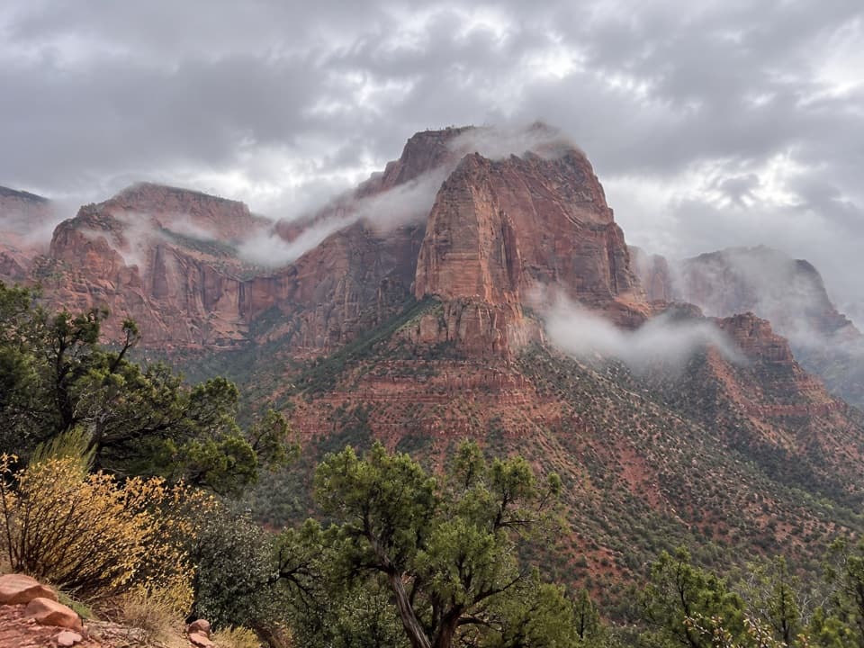
Taylor Creek Trail is a 5.2-mile out-and-back along the Middle Fork of Taylor Creek to Double Arch Alcove, a shaded sandstone recess at the end of a narrow canyon. The walk passes two early-1930s homestead cabins and the Kanarraville Fold before it reaches the alcove. Allow three to four hours. Choose it for the creek crossings, the canyon walls, and an unusual endpoint; you return the way you came.

Expect to get close to the creekFrom the trailhead, steps drop to Taylor Creek, then the route follows its corridor into the…

From the trailhead, steps drop to Taylor Creek, then the route follows its corridor into the canyon. Crossings come repeatedly. In low water, stepping stones sometimes keep shoes dry, but seasonal flow can turn this into a wet-foot hike. Wear shoes you are willing to get wet and bring a pole if it helps with balance. Much of the tread is firm soil or soft sand, with boulders and short stair-like sections. The first descent is brief; you climb back to the parking area at the end.

Two cabins and a folded ridgeNear the North Fork confluence, a short spur reaches the Larson Cabin.

Near the North Fork confluence, a short spur reaches the Larson Cabin. Gustav Larson built it in 1930 from white-fir logs hauled by wagon from Cedar City, then spent summers here from 1930 to 1933 raising pigs. Farther up the Middle Fork, the Fife Cabin sits on a bench above the north bank. Arthur Fife built that cabin in 1930. The trail also passes the Kanarraville Fold, where the sandstone layers bend into broad curves along the canyon wall.

What Double Arch Alcove actually isThe name makes it sound like a hole through the rock, but the destination is a deep alcove cut…

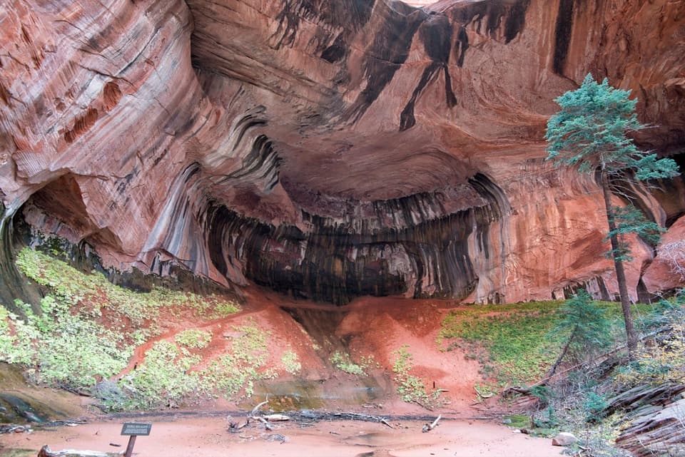
The name makes it sound like a hole through the rock, but the destination is a deep alcove cut by water into Navajo sandstone. Its broad overhang is shaded, with dark and pale seepage streaks running down the curved wall. Give yourself a few minutes to look up at the layers. For a photo, keep part of the overhang and the red ground in frame so the size of the recess reads clearly.

What makes the walk harderThe route is moderate overall, but it is not a smooth stroll.

The route is moderate overall, but it is not a smooth stroll. Water level changes how the crossings feel, and sandy stretches, large rocks, and steps demand attention. Winter can bring ice; spring flow can wet feet. The trail reaches Zion Wilderness, where groups are limited to 12 people who share an affiliation. Pets are not allowed on Kolob Canyons trails.

Getting to the startUse Taylor Creek Trailhead on Kolob Canyons Road.

Use Taylor Creek Trailhead on Kolob Canyons Road. It is roughly an hour from Zion Canyon, and no shuttle serves this part of the park, so plan it as its own outing. Pit toilets are at the trailhead; restrooms and water-bottle filling are at Kolob Canyons Visitor Center, with no water or food service found along the route. Park entry fees apply, but there is no separate activity fee or reservation. Visitor reports say trailhead parking can fill on busy days, though availability varies; an earlier start gives you a better chance at a space.

Wildlife

Wildlife in Zion

All Zion wildlife maps

Sighting maps show where each species has been reported across Zion. Wildlife moves, so no sighting is guaranteed.

Keep exploring

Near Taylor Creek Trail

See it all on the map

Trails that start nearby

Places near the trailhead

Parkwolf’s Zion ranking

Top-rated trails in Zion

All 54 trails
  1. 1Angels Landing TrailChallenging · 4.2 mi
  2. 2The Narrows from the Bottom UpChallenging · 9.4 mi
  3. 3Canyon Overlook TrailModerate · 1 mi
  4. 4East Mesa Trail to Observation PointModerate · 6.8 mi
  5. 5Left Fork (Subway) Bottom-UpChallenging · 9 mi
  6. 6West Rim Trail (Top-Down)Challenging · 14.6 mi

Take Parkwolf to Zion.

The audio tour guide for the drive, plus offline maps, trails, and wildlife heatmaps for when the signal drops.

4.7 from 8,600+ ratings

Download Parkwolf on the App StoreGet Parkwolf on Google Play