Parking
Start at Lee Pass Trailhead on Kolob Canyons Road. Parking capacity and fees were not verified. Arrange a ride to Lee Pass and an exit from The Grotto before starting; the two ends are far apart.

Zion National Park, UT
A backcountry crossing from Kolob's creek canyons to Zion Canyon.
Overview
Map & elevation
Plan your hike

The highest, rockiest slopes around here are a summer buffet for grizzly bears.
Zion Tour Guide
Parkwolf is a GPS audio tour guide for Zion National Park. As you drive, it chimes in with what’s ahead: hidden gems, upcoming stops, history, geology, and wildlife, right through your car’s speakers.
See the Zion audio tourRecorded for this trailhead
Lee Pass and Kolob Arch“Lee Pass Trailhead is ahead, the starting point for a long canyon walk to Kolob Arch. Plan on a strenuous fourteen-mile round trip taking seven to nine hours, with red cliffs and La Verkin Creek along the way.”
Plays as you drive up to this trailhead in the Parkwolf Zion Tour Guide.
More stories near here in the app
“Fantastic app with many points of information… It’s great to just turn on while you’re driving and it gives you an audio tour of the national Park. We love it!!!!”


Trail guide
The Trans-Zion Trek is about 37 miles one way, from Lee Pass Trailhead in Kolob Canyons to The Grotto in Zion Canyon. It links La Verkin Creek, Hop Valley, Connector, Wildcat Canyon and the scenic West Rim in a north-to-south crossing. Plan three to four days and sort out transport to both ends before you start. Overnight hikers need a Zion Wilderness permit and a campsite itinerary; the park limits groups to 12.
From Lee Pass, the route winds through open Kolob canyons, then drops on hard-packed trail to La Verkin Creek. It follows the creek below red cliffs, with a few crossings that can be difficult after heavy rain. Kolob Arch is a separate side trip, not part of the through-route distance.
Hop Valley changes the footing: the trail descends into a flat, sandy valley enclosed by high walls. Sand can turn wet and muddy, and cattle use parts of the valley near private inholdings. That matters for water planning as well as pace.
The Connector leaves the valley for slickrock and ponderosa forest, with views over upper Coalpits Wash and a climb below Pine Valley Peak. Wildcat Canyon then wanders through pine woods and open meadows before reaching the canyon rim. The view drops into Wildcat Canyon; after crossing the rim country, the trail climbs gently to meet the West Rim.
The high section passes Potato Hollow and Phantom Valley, with broad views into canyons on both sides. Follow the scenic West Rim route rather than the Telephone Canyon shortcut. At Cabin Spring, the character changes fast: the trail loses about 2,500 feet in 4.7 miles on a steep descent through pale cliffs, much of it cut into the rock or paved. It is a demanding finish after several days on foot. The route ends at The Grotto in Zion Canyon.
You move from creekside cliffs and sandy canyon floor to high forest, open plateau and Zion's deep main canyon. The park's exposed rock layers were deposited roughly 110 to 270 million years ago; uplift and the Virgin River later carved the cliffs and canyons the route crosses. Ponderosa pine, quaking aspen and mixed conifer mark the higher country.
Wildlife
 291 sightingsCalifornia CondorMost seen around 11 AMSighting map
 350 sightingsBighorn SheepMost seen around 7 AMSighting map
 22 sightingsMountain LionMost seen around 7 PMSighting map
 1,326 sightingsMule DeerMost seen around 6 AMSighting map
 23 sightingsGolden EagleMost seen around 10 AMSighting map
 15 sightingsPeregrine FalconMost seen around 7 AMSighting map
Sighting maps show where each species has been reported across Zion. Wildlife moves, so no sighting is guaranteed.
Keep exploring
 ChallengingLa Verkin Creek Trail to Kolob Arch14 mi · 8 hr · At the trailheadA long creek walk earns a distant view of Kolob Arch.
 ChallengingLa Verkin Creek Trail to Bear Trap Canyon Falls18.1 mi · 11 hr · At the trailheadAn 18-mile out-and-back to Bear Trap Canyon Falls in red sandstone.
 ModerateSouth Fork of Taylor Creek Trail3 mi · 3 hr · 0.4 mi awayA sandy canyon path beneath Kolob’s high red walls.
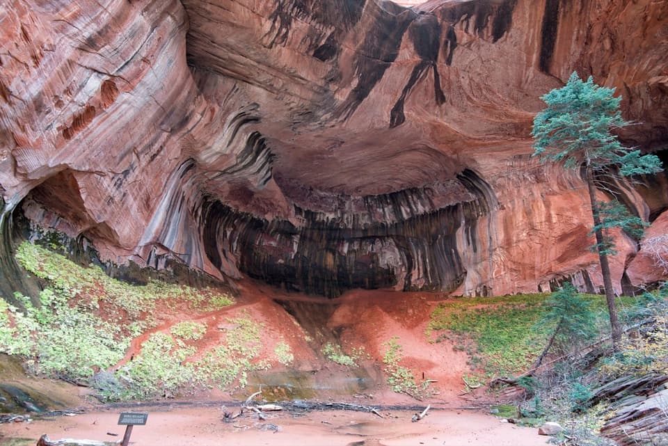 ModerateTaylor Creek Trail5.2 mi · 3.5 hr · 0.8 mi awayTwo homestead cabins lead to a shaded sandstone alcove.
 ModerateNorth Fork of Taylor Creek5.5 mi · 4 hr · 0.8 mi awayA quiet canyon walk, an easy to miss fork and small arch.
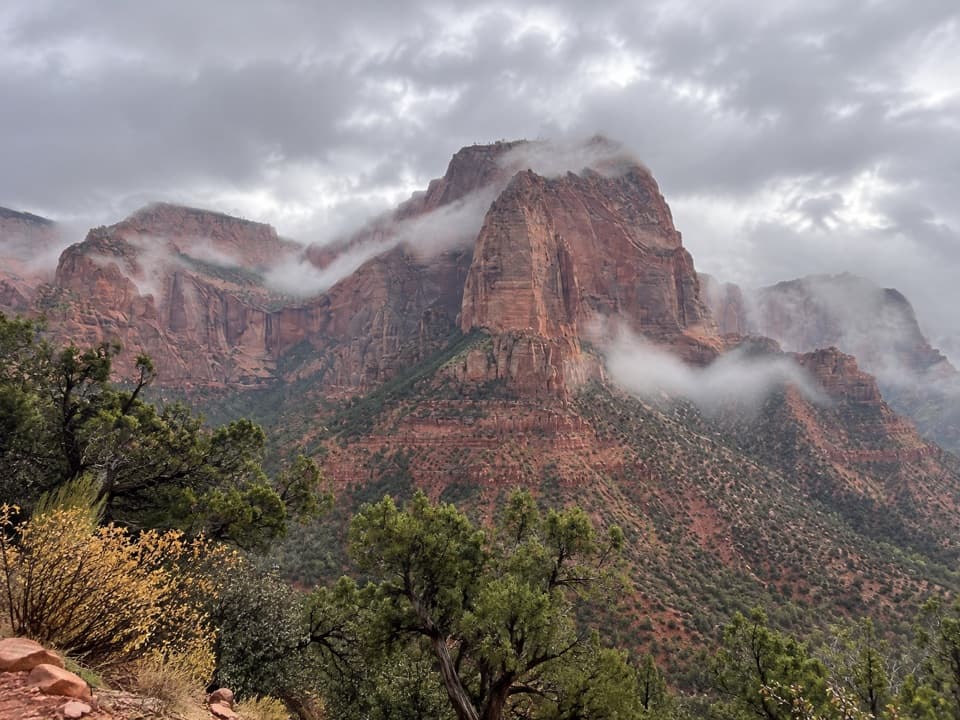 EasyTimber Creek Overlook Trail1.2 mi · 45 min · 1.3 mi awayShort ridge, red cliffs, and a long look toward Pine Valley.
 ChallengingCamp Creek Hike8.5 mi · 5.5 hr · 3.6 mi awayA rough canyon walk to twin stone portals and pitted red walls
 ModerateConnector Trail5.1 mi · 2.5 hr · 8.8 mi awayOpen meadows and slickrock connect two Kolob trailheads.
 Sight · 0.8 mi awayLarson CabinA 1931 log cabin marks a homestead that never quite took hold.
 Sight · 1.3 mi awayKolob Canyons ViewpointA five-mile drive earns a sweeping view of red finger canyons.
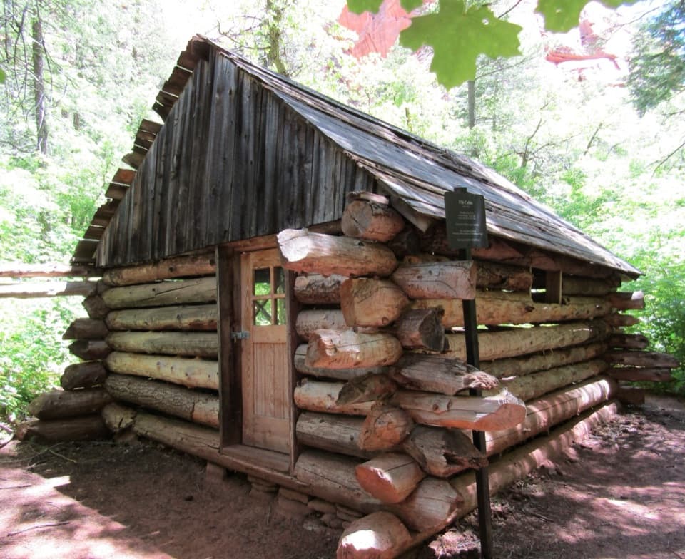 Sight · 1.3 mi awayFife CabinA small 1930s homestead gives the creek hike a human story.Sight · 1.6 mi awayDouble Arch AlcoveA streaked sandstone alcove caps a creek-crossing hike.
 Sight · 1.8 mi awayTimber Creek OverlookA rocky ridge walk to Kolob’s wide southern horizon.
 Visitor center · 1.9 mi awayKolob Canyons Visitor CenterYour required pass stop before Kolob's five-mile scenic road.
 Sight · 3 mi awayKolob ArchA full-day canyon hike to an arch you see from afar.
 Campground · 9.9 mi awayLava Point CampgroundSix tent sites on Zion's high, remote Kolob Terrace.
Parkwolf’s Zion ranking

The audio tour guide for the drive, plus offline maps, trails, and wildlife heatmaps for when the signal drops.




