Waterlemon Cay in Virgin Islands National Park

#5 of 38 sights in Virgin Islands

Sight · Virgin Islands National Park

Waterlemon Cay

A reef-ringed cay, reached by a real open-water swim.

Photo: Public Domain
Type
Sight
Nearest trail
0.2 mi
Audio stories
10 nearby

Hear the audio tour

Waterlemon Cay via Leinster Bay

Overview

About Waterlemon Cay

Why stop

  • Coral, reef fish and often-reported turtles reward snorkelers.
  • The shoreline approach opens onto views across a historically layered bay.

Heads up

  • The exposed rocky walk and open-water crossing take more effort than a beach stop.
Waterlemon Cay is a small, low islet off Leinster Bay, best known for the reef snorkeling around it. This is a shore walk followed by an open-water swim, not a drive-up beach stop. From Annaberg, allow about a mile each way along a mostly flat but rocky, sun-exposed shoreline trail to the closest launch, usually around 20 to 30 minutes of walking each way. From there it is roughly 500 to 600 feet of open water to the cay. If that swim is beyond your comfort zone, the bay has shallower reef access before you reach the island.
Parkwolf’s verdictIs the swim right for you?

Map

Where it is

Loading the Virgin Islands map
Full map
SightWaterlemon Cay18.36708, -64.72293
Keep this map with you offline in the Parkwolf app

Plan your stop

Before you go

1 active Virgin Islands alert

  • ClosureCaneel Bay restricted areas and closed pierAt Caneel Bay, use only designated public areas; other areas and the pier remain closed. - Areas beyond the public areas remain closed because of present safety risks.Official details

Virgin Islands alerts
A park ranger sits on a dash-mounted phone, talking, as Parkwolf’s Tour Guide plays “Army Cutworm Moths: A Grizzly Bear Buffet” on Grand Loop Road below Dunraven Pass in Yellowstone
Parkwolf Tour GuideThe highest, rockiest slopes around here are a summer buffet for grizzly bears.

Virgin Islands Tour Guide

Your drive to Waterlemon Cay, narrated.

Parkwolf is a GPS audio tour guide for Virgin Islands National Park. As you drive, it chimes in with what’s ahead: hidden gems, upcoming stops, history, geology, and wildlife, right through your car’s speakers.

Recorded for this place

Waterlemon Cay via Leinster Bay
0:00 / 0:24
“You're nearing the Leinster Bay trailhead, the walking access for Waterlemon Cay.”

Plays as you drive up to Waterlemon Cay in the Parkwolf Virgin Islands Tour Guide.

More stories near here in the app

  • Annaberg Sugar Plantation
  • The Firewood Delivery at Coral Bay
  • Francis Bay Beach and Salt Pond Boardwalk
  • Watch the Bananaquit’s Beak
  • 26 audio storiesacross Virgin Islands’s roads, triggered by GPS as you drive
  • Wildlife heatmapsfor White-tailed Deer, Green Iguana, Brown Pelican, and 13 more
  • Works offlinemaps, 22 trails, 42 places, and audio download before you lose signal
  • CarPlay readysimple controls built for the drive
★★★★★
“Fantastic app with many points of information… It’s great to just turn on while you’re driving and it gives you an audio tour of the national Park. We love it!!!!”
JMJamesApp Store review
Download Parkwolf on the App StoreGet Parkwolf on Google Play

4.7 from 8,600+ ratings

Guide

More about Waterlemon Cay

Read the water before you goThe north side of the cay, toward Tortola, has a strong current.

The north side of the cay, toward Tortola, has a strong current. Favor the southern side, and stand only on sand to avoid the sharp rocks and long-spined urchins around the entry. Conditions can shift with wind and waves, so don't treat a report of easy water as a promise. If you aren't comfortable swimming in open water, enjoy the closer reef from shore instead of pushing across.

What you may see underwaterThe reef around the cay is the point of the outing: coral and sea fans ring the island, with…

The reef around the cay is the point of the outing: coral and sea fans ring the island, with schools of reef fish moving through the shallows and the deeper edge. Visitors often report green turtles; rays, barracuda and nurse sharks show up in some accounts too. Those encounters are a bonus, never a guarantee.

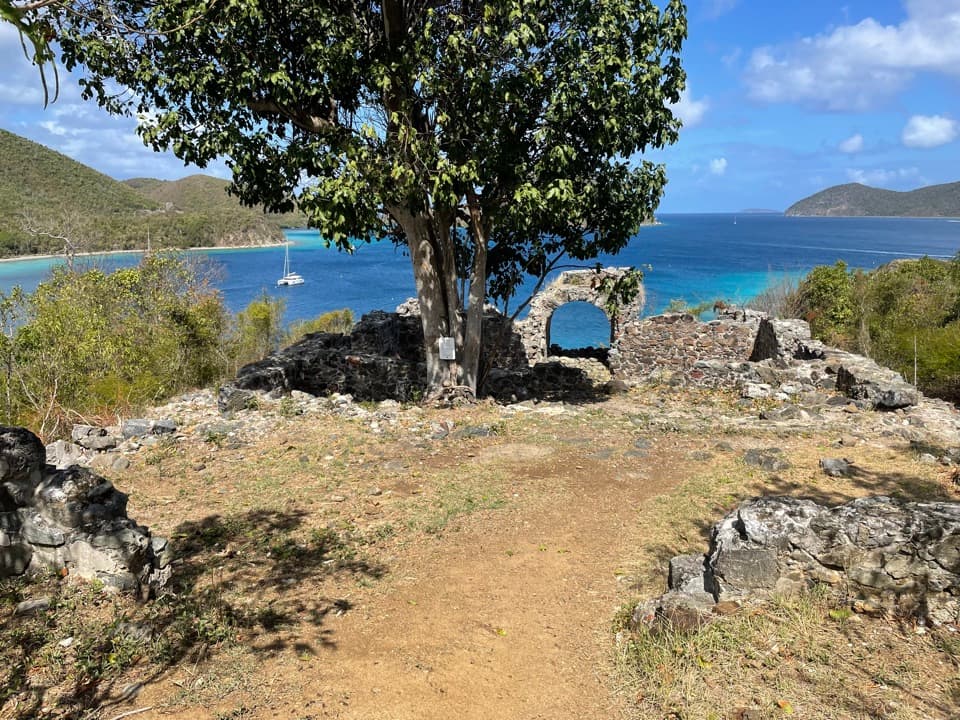
The walk follows a historic coastThe path from Annaberg follows the shoreline into Leinster Bay, past a remnant bridge and ruins…

The path from Annaberg follows the shoreline into Leinster Bay, past a remnant bridge and ruins associated with the old plantation coast. Those remains are along the approach, not on the cay itself. The walk is exposed and the small parking area at Annaberg serves the plantation ruins as well, so arriving earlier can make parking easier.

The history beneath the quietLeinster Bay was a working plantation landscape in the 18th and 19th centuries.

Leinster Bay was a working plantation landscape in the 18th and 19th centuries. Records from 1769 describe 50 acres of sugar cane, a sugar works and rum still, and 38 enslaved people on the estate. Keeping that history in view changes the feel of the otherwise quiet shoreline: it was once a populated, industrial coast built on enslaved labor.

A good view without the swimOpenings along the trail give you a clear look at the cay across the bay.

Openings along the trail give you a clear look at the cay across the bay. Frame the low island with water and the green hills behind it to show how small it is against the coast. The coral and fish views are underwater, though, so a shoreline photo is a different experience from snorkeling around the reef.

Wildlife

Wildlife in Virgin Islands

All Virgin Islands wildlife maps

Sighting maps show where each species has been reported across Virgin Islands. Wildlife moves, so no sighting is guaranteed.

Keep exploring

Near Waterlemon Cay

See it all on the map

Trails nearby

More stops nearby

Parkwolf’s Virgin Islands ranking

Top sights in Virgin Islands

All 42 places
  1. 1Trunk Bay BeachBeach
  2. 2Maho Bay BeachBeach
  3. 3Annaberg Sugar PlantationSight
  4. 4Cinnamon Bay BeachBeach
  5. 6Reef Bay PetroglyphsSight
  6. 7Trunk Bay OverlookSight

Take Parkwolf to Virgin Islands.

The audio tour guide for the drive, plus offline maps, trails, and wildlife heatmaps for when the signal drops.

4.7 from 8,600+ ratings

Download Parkwolf on the App StoreGet Parkwolf on Google Play