Cruz Bay Visitor Center in Virgin Islands National Park

Visitor center · Virgin Islands National Park

Cruz Bay Visitor Center

Start with the island model before choosing your first hike.

Type
Visitor center
Nearest trail
0.1 mi
Audio stories
9 nearby
  • Exhibit
  • Restrooms
  • Parking
  • Store

Hear the audio tour

Cruz Bay Visitor Center

Overview

About Cruz Bay Visitor Center

Why stop

  • Island map and helpful staff make route planning easier.

Heads up

  • A compact exhibit stop, not a full-scale museum.

Map

Where it is

Loading the Virgin Islands map
Full map
Visitor centerCruz Bay Visitor Center18.33275, -64.79379
Keep this map with you offline in the Parkwolf app

Plan your stop

Before you go

The building and useful facilities

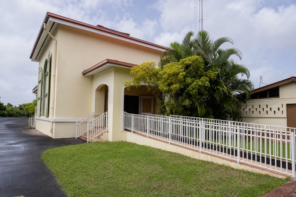
The pale-yellow building borrows its shape from a Danish West Indian warehouse; its dark-green shutters echo the carriage doors those warehouses used. There’s a ramp as well as stairs at the entrance, an accessible flush restroom, and a bottle-filling station with drinking water. A small Friends of Virgin Islands National Park shop sells park souvenirs and snacks, making this a handy quick stop rather than a meal stop.

Lind Point Trail begins just behind the center, and nearby parking also serves hikers heading for Lind Point or Caneel Hill. Parking capacity and current rules weren’t clear enough to describe, so check the posted NPS guidance if you’re planning to leave a car here.


3 active Virgin Islands alerts

  • ClosureCaneel Bay: designated areas only; pier closedAt Caneel Bay, stay in designated public areas; other areas remain closed because of present safety risks, and the pier remains closed because it has been deemed unsafe.Official details
  • CautionModerate rip-current risk at U.S. Virgin Islands beachesThe National Weather Service reports a moderate rip-current risk for the U.S. Virgin Islands. - Choose a guarded or more protected beach and swim near a lifeguard.Official details
See all 3 alerts
A park ranger sits on a dash-mounted phone, talking, as Parkwolf’s Tour Guide plays “Army Cutworm Moths: A Grizzly Bear Buffet” on Grand Loop Road below Dunraven Pass in Yellowstone
Parkwolf Tour GuideThe highest, rockiest slopes around here are a summer buffet for grizzly bears.

Virgin Islands Tour Guide

Your drive to Cruz Bay Visitor Center, narrated.

Parkwolf is a GPS audio tour guide for Virgin Islands National Park. As you drive, it chimes in with what’s ahead: hidden gems, upcoming stops, history, geology, and wildlife, right through your car’s speakers.

Recorded for this place

Cruz Bay Visitor Center
0:00 / 0:26
“You're coming up on Cruz Bay Visitor Center, a small orientation stop beside the harbor. Start with the island model: it shows how the roads, beaches and trails fit around St. John's hills.”

Plays as you drive up to Cruz Bay Visitor Center in the Parkwolf Virgin Islands Tour Guide.

More stories near here in the app

  • Caneel Hill Trail and Observation Deck
  • Lind Point, Honeymoon and Salomon Beaches
  • Caneel Beach and the Old Resort
  • Water Catchment Trail and the Old Basin
  • 26 audio storiesacross Virgin Islands’s roads, triggered by GPS as you drive
  • Wildlife heatmapsfor White-tailed Deer, Green Iguana, Brown Pelican, and 13 more
  • Works offlinemaps, 22 trails, 42 places, and audio download before you lose signal
  • CarPlay readysimple controls built for the drive
★★★★★
“Fantastic app with many points of information… It’s great to just turn on while you’re driving and it gives you an audio tour of the national Park. We love it!!!!”
JMJamesApp Store review
Download Parkwolf on the App StoreGet Parkwolf on Google Play

4.7 from 8,600+ ratings

Guide

More about Cruz Bay Visitor Center

Get your bearings before you set outCruz Bay Visitor Center is a small park orientation center on the harbor in Cruz Bay, serving…

Cruz Bay Visitor Center is a small park orientation center on the harbor in Cruz Bay, serving Virgin Islands National Park and Virgin Islands Coral Reef National Monument. It’s a useful first stop before choosing a beach or hike, especially if you’re arriving by ferry: the public dock is about a five-minute, two-block walk north along Route 20. This is a compact visitor center, not a full-scale museum.

Inside, a topographic model lays out St. John’s roads, beaches, trails and the park boundary. The staff desk and brochures are at the end of the exhibit route, so you can get a map and ask about your next stop after seeing the island in context.

Island history in a compact spaceThe exhibits move from the island’s first inhabitants into colonial St.

The exhibits move from the island’s first inhabitants into colonial St. John, plantation life and the history of enslavement. Taíno displays include pottery and stone-tool replicas; plantation-era cases use tools and other objects to show how sugar production shaped the island. The 1733 revolt has its own section, followed by examples of local Virgin Islander crafts made after emancipation, including baskets and fish traps.

Reefs and habitatsCoral samples and a reef diorama introduce the marine ecology around St. John.

Coral samples and a reef diorama introduce the marine ecology around St. John. Other displays focus on the shoreline and its crabs, shorebirds, nesting sea turtles and coastal plants, then shift inland to bats, frogs and lizards. These are exhibit subjects rather than a promise of wildlife sightings at the center itself.

The harbor-facing viewThe center’s yellow walls and deep-green shutters stand out against the waterfront.

The center’s yellow walls and deep-green shutters stand out against the waterfront. For a useful building photo, keep those details in frame and pull back enough to show some of the harbor setting; the boats and water make it clear why the visitor center sits right at Cruz Bay.

Wildlife

Wildlife in Virgin Islands

All Virgin Islands wildlife maps

Sighting maps show where each species has been reported across Virgin Islands. Wildlife moves, so no sighting is guaranteed.

Keep exploring

Near Cruz Bay Visitor Center

See it all on the map

Trails nearby

More stops nearby

Parkwolf’s Virgin Islands ranking

Top sights in Virgin Islands

All 42 places
  1. 1Trunk Bay BeachBeach
  2. 2Maho Bay BeachBeach
  3. 3Annaberg Sugar PlantationSight
  4. 4Cinnamon Bay BeachBeach
  5. 5Waterlemon CaySight
  6. 6Reef Bay PetroglyphsSight

Take Parkwolf to Virgin Islands.

The audio tour guide for the drive, plus offline maps, trails, and wildlife heatmaps for when the signal drops.

4.7 from 8,600+ ratings

Download Parkwolf on the App StoreGet Parkwolf on Google Play